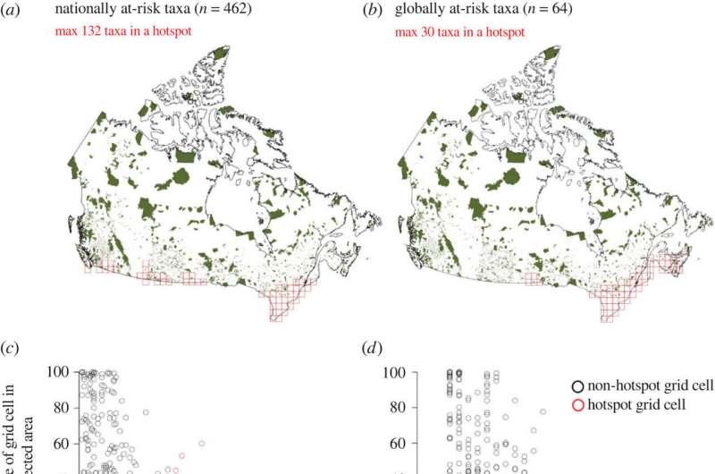
Habitat protectionof nationally at-risk taxa (left) and globally at-risk taxa (right) in Canada. (a,b) location of Canada's publicly protected and conserved areas (green), and hotspots of at-risk taxa (from figure 1) outlined in red. (c,d)Protection tends to increase with the number of at-risk taxa in non-hotspot cells (black), but not for cells that are hotspots of at-risk taxa (red). Each point represents one of the 1276 grid cells in Canada. Trends lines and shading for visualization were extracted from beta-GLMs; since these do not account for potential spatial autocorrelation, true 95% CI are likely to be wider. (e,f) Percentage of at-risk taxa's Canadian range included in protected areas. Differing letters represent significant differences among (e) COSEWIC threat statuses (Model 4) or (f) IUCN threat statuses (Model 5). Sample sizes are in table 1. Box plot formats are as in figure 2. Credit: Proceedings of the Royal Society B: Biological Sciences (2023). DOI: 10.1098/rspb.2022.2307
At the recent COP 15 conference in Montreal, Canada committed to protecting 30% of its land by 2030, but which areas are most crucial to protect for at-risk species such as the spotted turtles?
In a new study published in the Proceedings of the Royal Society B: Biological Sciences, McGill University researchers overlayed maps of species at risk to find hotspots where many species live together. They found that hotspots often overlap. For example, more than half the hotspots for at-risk birds are also hotspots for at-risk insects.
One of these 100 square kilometer areas could contain more than 130 at-risk species. "If protected areas are put in the right places, protecting a small fraction of Canadian land could protect habitat for many at risk species," said co-author and Biology Professor Anna Hargreaves.
But the researchers say the clock is ticking. Only 3.8% of the most valuable land for conservation is currently protected. More than 2/3 of at-risk species in Canada have less than 10% of their Canadian range protected, according to the researchers, and the most endangered species have the least protection.
"Most hotspots are in southern Ontario and Quebec where there is little natural land left and what remains is threatened by ongoing clearing and development," said Hargreaves. The researchers hope their work can help governments do a better job of safeguarding at-risk species.
More information: Marie E. Hardouin et al, Mapping nationally and globally at-risk species to identify hotspots for (and gaps in) conservation, Proceedings of the Royal Society B: Biological Sciences (2023). DOI: 10.1098/rspb.2022.2307
Journal information: Proceedings of the Royal Society B
Provided by McGill University


