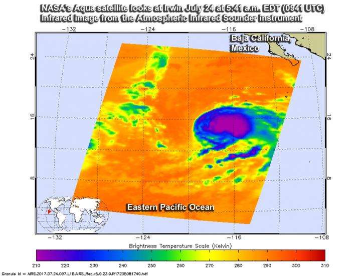
On July 24 at 5:41 a.m. EDT (0941 UTC) the AIRS instrument aboard NASA's Aqua satellite captured this infrared image of Irwin when it was still a tropical storm. The image showed a large area of powerful storms with very cold cloud tops (purple) surrounding the center. Credit: NASA JPL/Ed Olsen
NASA's Aqua satellite passed over Tropical Storm Irwin as it was strengthening toward hurricane status. Aqua gathered temperature data using infrared light that revealed the power building within.
It was the Atmospheric Infrared Sounder or AIRS instrument aboard NASA's Aqua satellite that looked at Tropical Storm Irwin in infrared light. Infrared light provides scientists with temperature data and that's important when trying to understand how strong storms can be. The higher the cloud tops, the colder and the stronger they are. So infrared light as that gathered by the AIRS instrument can identify the strongest storms within a tropical cyclone.
AIRS infrared data gathered on July 24 at 5:41 a.m. EDT (0941 UTC) showed a large area of strong storms with cloud top temperatures as cold as minus 63 degrees Fahrenheit (minus 53 degrees Celsius). NASA research has shown that cloud tops that cold, which are high in the troposphere, have the ability to generate heavy rainfall.
Those powerful storms around the center were likely "hot towers." A "hot tower" is a tall cumulonimbus cloud near the center of a tropical cyclone, often seen prior to intensification. The cloud tops reach at least to the top of the troposphere, the lowest layer of the atmosphere which is approximately 9 miles/14.5 km high in the tropics. These towers are called "hot" because they rise to such altitude due to the large amount of latent heat. Water vapor releases this latent heat as it condenses into liquid. Those towering thunderstorms have the potential for heavy rain. Energy released by rainfall into the center of a tropical cyclone provides the energy upon which tropical cyclones thrive.
Less than 12 hours later, Irwin strengthened into a hurricane. At 5 a.m. EDT (0900 UTC) on July 25, maximum sustained winds had increased to near 75 mph (120 kph) with higher gusts.
The center of Hurricane Irwin was located near 15.5 degrees north latitude and 118.7 degrees west longitude. That's about 770 miles (1,235 km) southwest of the southern tip of Baja California, Mexico. Irwin also lies west of Hurricane Hilary and like Hilary, Irwin is a small hurricane with hurricane-force winds extending only out to 15 miles (30 km) from the center.
Irwin was moving toward the west-northwest near 5 mph (7 kph) and the National Hurricane Center expects it to turn west later in the day, followed by a movement to the west-southwest on July 28.
Little change in strength is expected on July 27 with weakening expected on Wednesday.
Provided by NASA's Goddard Space Flight Center


