NASA infrared imagery shows wind shear blowing Cyclone 14P apart

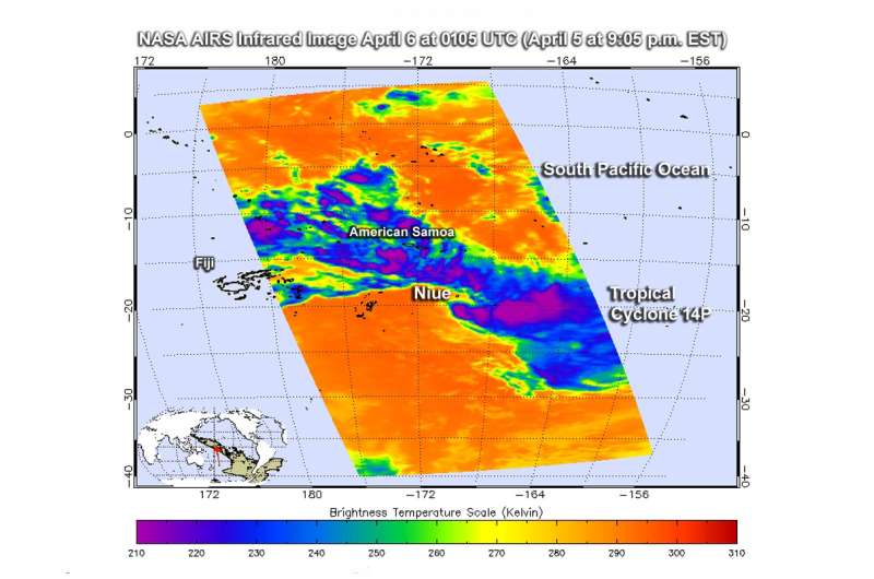
NASA's Aqua satellite passed over Tropical Cyclone 14P gathering data in infrared light and observed that westerly wind shear pushed the strongest storms east of the center. The strong winds were shearing the storm apart.
The Atmospheric Infrared Sounder or AIRS instrument aboard NASA's Aqua satellite looked at Tropical Cyclone 14P in infrared light. Infrared light provides scientists with temperature data and that's important when trying to understand how strong storms can be. The higher the cloud tops, the colder and the stronger they are. So infrared light as that gathered by the AIRS instrument can identify the strongest sides of a tropical cyclone.
NASA's Aqua satellite flew over Tropical Cyclone 14P on April 6 at 0105 UTC (April 5 at 9:05 p.m. EST). AIRS detected strongest storms east of the center of circulation with cloud top temperatures as cold as minus 63 degrees Fahrenheit (minus 53 degrees Celsius). Those storms were being pushed east by strong vertical westerly wind shear. Storms with cloud top temperatures that cold have the capability to produce heavy rainfall.
The Joint Typhoon Warning Center's or JTWC noted that "The associated convection has significantly sheared (pushed) eastward of the low level circulation and has become unraveled."
At 11 a.m. EST (1500 UTC) on April 6, the maximum sustained winds of Tropical Cyclone 14S dropped to 30 knots (34.5 mph/55.5 kph) and were weakening. The center of 14P was located near 20.9 degrees south latitude and 169.8 degrees west longitude. That's about 102 nautical miles (117 miles/189 km) south of the island of Niue. 14P was moving to the southeast at 3 knots (3.4 mph/5.5 kph).
Tropical Cyclone 14P has weakened to below the JTWC warning criteria. JTWC's final warning on 14P noted "upper level (atmosphere) analysis indicates the cyclone has drifted into an area of strong vertical wind shear between 30 knots (34.5 mph/55.5 kph) to 40 knots (46 mph/74 kph). The storm is expected to continue weakening and dissipate under adverse conditions.
Provided by NASA's Goddard Space Flight Center


