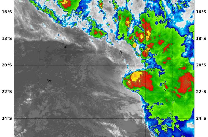
Aqua satellite spots development of Tropical Storm 14P in South Pacific Ocean

NASA's Aqua satellite analyzed cloud top temperatures in newly formed Tropical Cyclone 14P in the Southern Pacific Ocean. Infrared data showed strongest thunderstorms were on one side of the tropical cyclone as a result of wind shear.
At 8:55 a.m. EST (1255 UTC) on April 5, infrared data from the Moderate Resolution Imaging Spectroradiometer aboard NASA's Aqua satellite showed Tropical Cyclone 14P contained storms with cloud top temperatures as cold as minus 70 degrees Fahrenheit (minus 56.6 degrees Celsius). Temperatures that cold suggest that the cloud tops are high in the troposphere. They are usually powerful storms that generate heavy rainfall. The infrared data showed the strongest storms were east of the center of circulation as the storm was being affected by westerly vertical wind shear.
At 11 a.m. EST (1500 UTC), the Joint Typhoon Warning Center (JTWC) noted that maximum sustained winds were near 35 knots (40 mph/62 kph) making it a tropical storm. Tropical Storm 14P is moving to the west-southwestward at 6 knots (7 mph/11 kph). 14P was located near 20.2 degrees south latitude and 171.3 degrees west longitude, about 91 nautical miles (104.7 miles/168.5 km) southwest of Niue. Niue is a small island nation in the South Pacific Ocean located about 2,400 kilometers (1,500 miles) northeast of New Zealand.
JTWC noted that the system is not expected to have a long life because it is forecast to move into adverse conditions. JTWC said "The cyclone may have a short window of weak intensification while outflow and sea surface temperatures remain supportive during this period. However, Beyond 24 hours, an approaching trough (elongated area of low pressure) from the west will begin to recurve 14P sharply southward into an area of stronger vertical wind shear and colder sea surface temperatures, resulting in full dissipation of the system by 48 hours."
Provided by NASA's Goddard Space Flight Center


