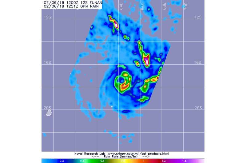
The GPM Core Observatory passed over Tropical Storm Funani at 7:51 a.m. EDT (1251 UTC). GPM found the heaviest rainfall was southwest of the center of circulation. There, rain was falling at a rate of 1.2 inches per hour. Credit: NASA/JAXA/NRL
Tropical Storm Funani (formerly classified as 12S) continued to affect Rodrigues Island in the South Pacific Ocean when the GPM satellite passed overhead and analyzed its rainfall.
On Feb. 6, a tropical cyclone warning class 2 is in force at Rodrigues, with cyclonic conditions starting to occur from late evening (local time).
The Global Precipitation Measurement mission, or GPM, Core Satellite passed over Tropical Storm Funani at 7:51 a.m. EDT (1251 UTC). GPM found the heaviest rainfall was southwest of the center of circulation. There, rain was falling at a rate of 1.2 inches per hour. Other areas of heavy rainfall were occurring in fragmented bands of thunderstorms east of the center. GPM is a joint mission between NASA and the Japan Aerospace Exploration Agency, JAXA.
At 11 a.m. EDT (1500 UTC), the center of Tropical Cyclone Funani was located near latitude 17.5 degrees south and longitude 64.4 degrees east. That's about 432 nautical miles east-northeast of Port Louis, Mauritius. Maximum sustained winds were near 65 knots (75 mph/120 kph), making it a Category 1 hurricane on the Saffir-Simpson Hurricane Wind Scale.
The Joint Typhoon Warning Center noted Funani is rapidly strengthening as it moves southeast. The storm will intensify to 105 knots (121 mph/192 kph) within two days, before starting to weaken.
Provided by NASA's Goddard Space Flight Center


