NASA's GPM examines weaker Tropical Storm Yutu's rainfall

Typhoon Yutu produced heavy rainfall as it passed over the island of Luzon in the northern Philippines. The Global Precipitation Measurement mission or GPM core satellite provided data on that rainfall. The storm has since weakened to a tropical storm and triggered warnings in China.
At least nine deaths have been attributed to the typhoon. Heavy rainfall caused a landslide in the town of Natonin where up to 24 people are still missing. As expected, the typhoon weakened as is passed over the mountainous terrain of northern Luzon.
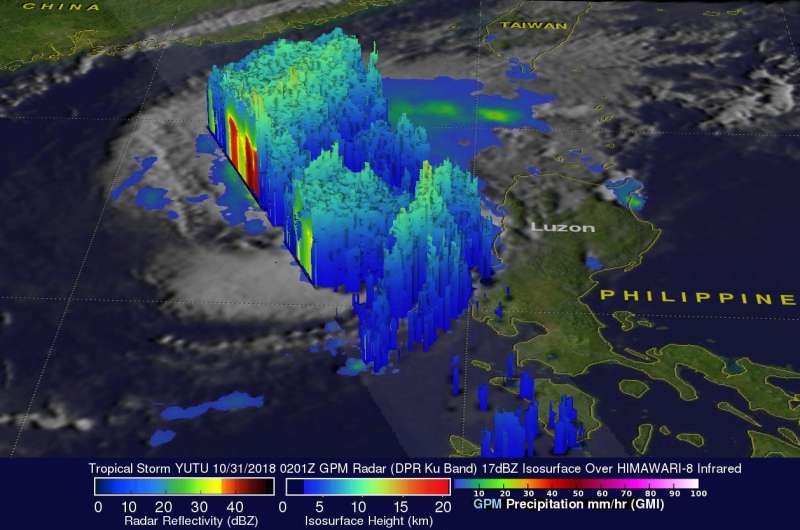
The GPM core observatory satellite had an excellent view of Tropical Storm Yutu on October 31, 2018 at 0210 UTC (Oct. 30 at 10:10 p.m. EDT) as it passed directly above the center of circulation. At the time GPM passed overhead, Tropical Storm Yutu had maximum sustained winds of about 55 knots (63 mph) and was moving over the South China Sea. A rainfall analysis based on GPM's Microwave Imager (GMI) and Dual-Frequency Precipitation Radar (DPR) instruments showed that very little rainfall was occurring near the tropical storm's low level center of circulation. Extremely heavy rainfall was found by the satellite's radar in powerful storms located northwest and southeast of Yutu's center of circulation. GPM's radar (DPR Ku Band) measured precipitation in those areas falling at the exceptional rate of greater than 183 mm (7.2 inches) per hour.
At NASA's Goddard Space Flight Center in Greenbelt, Md. a 3-D view of tropical storm Yutu was constructed using data from GPM's radar (DPR Ku Band). The image, looking from the south showed the vertical structure of precipitation within the tropical storm. Those data revealed that storm top heights were reaching altitudes above 15.5 km (9.6 miles) in the tallest convective storms that were located well to the northwest of Yutu's center of circulation. GPM is a joint mission between NASA and the Japan Aerospace Exploration Agency, JAXA.
On Nov. 1, the Hong Kong Observatory posted a Tropical Cyclone Warning Bulletin on Yutu 21:45 HKT (9:45 a.m. EDT) and noted that the Strong Wind Signal, No. 3 is in force. This means that winds with mean speeds of 41 to 62 kilometers (25 to 39 mph) per hour are expected.
On Nov. 1 at 11 a.m. EDT (1500 UTC), the Joint Typhoon Warning Center noted that satellite imagery shows disorganized deep convection (developing thunderstorms) becoming displaced to the northeast of a poorly defined low-level circulation center." At that time, Tropical Storm Yutu had maximum sustained winds near 40 knots (46 mph/74 kph). It was centered near 20.7 degrees north latitude and 116.3 degrees east longitude. Tropical storm Yutu was located approximately 160 nautical miles southeast of Hong Kong, China and was moving north.
The bulk of clouds and precipitation is being pushed to the northeast from strong wind shear. In general, wind shear is a measure of how the speed and direction of winds change with altitude. In order to understand how it affects a tropical cyclone or hurricane, think of a tropical cyclone as a vertical rotating cylinder. The different levels of rotating winds in the center of Tropical cyclones need to be stacked on top each other for the storm to strengthen. If there are outside winds pushing against the cylinder near the top, it affects the balance of the entire cylinder and that's what happens when vertical wind shear pushes against a storm. It pushes the center and weakens (or wobbles) the rotation of the entire cylinder (storm).
The Joint Typhoon Warning Center (JTWC) predicts that Tropical Storm Yutu will turn toward the northwest, gradually weaken and dissipate as it moves toward Hong Kong.
Provided by NASA's Goddard Space Flight Center


