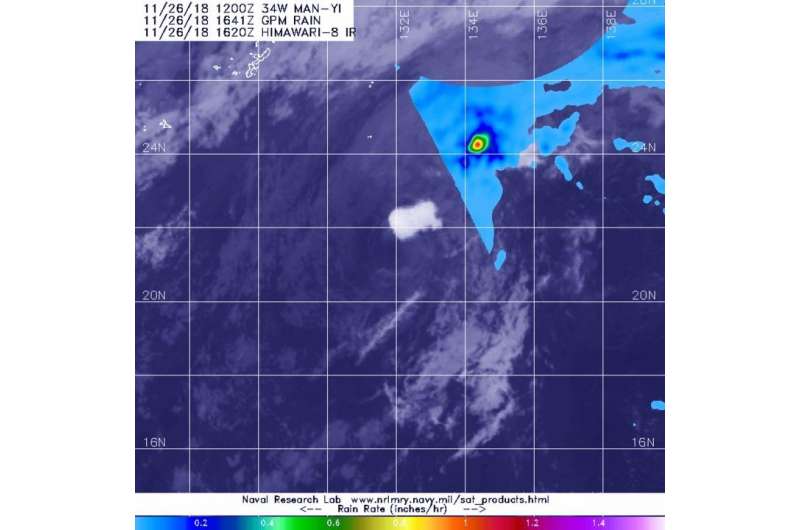
NASA's GPM shows small area of heavy rain in Tropical Storm Man-yi

Once a typhoon, Man-yi has weakened to a tropical storm as it continues to track through the Northwestern Pacific Ocean, far to the east of Taiwan. The GPM core satellite provided a look at the rain rates throughout the storm and found heaviest rain displaced to the northeast of the center.
The Global Precipitation Measurement mission or GPM core observatory satellite is a joint satellite mission between NASA and the Japan Aerospace Exploration Agency called JAXA. GPM provided an analyzation of rainfall within Man-yi on Nov. 26 at 11:41 a.m. EST (1641). Microwave Imager (GMI) instruments revealed heaviest estimated precipitation was falling at a rate of greater than 30 mm (1.2 inches) per hour northeast of the center of circulation.
That heaviest rainfall was displaced from the center because of moderate vertical wind shear pushing it from the center. In general, wind shear is a measure of how the speed and direction of winds change with altitude. Wind shear can tear a tropical cyclone apart or weaken it.
At 10 a.m. EST (1500 UTC) on Nov. 26, Man-yi was a weak tropical storm with maximum sustained winds near 35 knots (40 mph/74 kph). It was centered near 21.4 north latitude and 132.1 east longitude, about 406 nautical miles southeast of Kadena Air Base, Okinawa Island, Japan. Man-yi has tracked north-northwestward.
Many-yi is expected to maintain strength for another day and then be absorbed by the mid-latitude westerlies (winds) and begin extra-tropical transition. Man-yi is expected to be fully transitioned into an extra-tropical cyclone by Nov. 28. That means that a tropical cyclone has lost its "tropical" characteristics. The National Hurricane Center defines "extra-tropical" as a transition that implies both poleward displacement (meaning it moves toward the north or south pole) of the cyclone and the conversion of the cyclone's primary energy source from the release of latent heat of condensation to baroclinic (the temperature contrast between warm and cold air masses) processes. It is important to note that cyclones can become extratropical and still retain winds of hurricane or tropical storm force.
Provided by NASA's Goddard Space Flight Center


