This animation shows the differences in vegetation development detected by the Copernicus Sentinel-2 satellites in the Emmeloord region of the Netherlands between August 2017 and August 2018. The effects of the drought are clear here with a significant shift from lush greens in 2017 to brown shades the following year clearly visible. Credit: contains modified Copernicus sentinel data (2018), processed by ESA/GeoVille
The drought that swept through Europe this year has hit European farmers hard. Sustained high temperatures and the lack of rain have badly affected the agrofood industry, including the important potato sector.
Europe has the highest level of potato consumption in the world at almost 90 kg per capita per year, and is the second largest potato producer globally with some 53 million tonnes harvested annually.
The price of potatoes varies from year to year, but this important crop has now reached the highest value seen in recent years on the commodity futures exchange.
All of this, of course, means that the French fries, so well-loved in Europe, are about to get more expensive.
It is not all doom and gloom though. Earth observation data, including Copernicus Sentinel-1 and Sentinel-2 satellites as well as very high resolution data from other missions, can be used to help mitigate a number of challenges faced by the industry, from storage to disease monitoring, while increasing logistics and trading efficiencies.
A new service will help reduce the effect of these problems using satellite data.
The agrofood industry and farmers growing potatoes and other crops should soon save money, get better prices and help protect their crops from disease using satellite data collected that will be sent directly to them through ESA's novel EOPLUG-IN service.
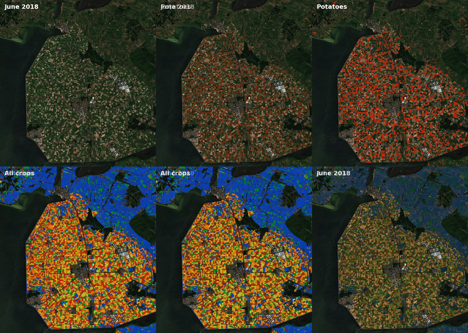
This animation shows early season crop type classification in the Emmeloord region of the Netherlands in June 2018 based on Copernicus Sentinel-2 data. Green shows summer crops, red: potatoes, orange: vegetables and flowers, yellow: cereals, and blue: grass. Credit: contains modified Copernicus Sentinel data (2018), processed by ESA/GeoVille
The service will help with storage, trading and disease monitoring. This will help growers conserve potatoes better and longer, assist trading decisions, and improve the detection of certain diseases to reduce losses.
EOPLUG-IN, recently launched through ESA's new Earth observation innovation hub – the ɸ-lab, will enable fast, easy access to continuous business intelligence data streams for industry via machine-based technologies.
This system will provide the means to integrate satellite data and other information streams directly in existing industry workflows in a business-friendly format. This will inform the agrofoood industry, for example, about the impact of ongoing droughts, crop failures and diseases, helping users to save money, get better prices, and as a result, also help make potatoes cheaper for European consumers.
Janny Peltjes, the managing director of HLB BV, a member of the Dutch agrofood cluster, expects that "the novel satellite-based system will be able to spatially detect crop diseases, thereby providing means to efficiently target affected areas, saving pesticide application and safeguarding production".
As the system is scalable, the services can be expanded to different topics and sectors. Agriculture is a low margin industry and increasing margins on the 53 million tonnes of potatoes produced in Europe each year will save millions for this €7 billion industry.
The service is developed by GeoVille Information Systems and Data Processing GmbH, the Austrian Earth Observation Data Centre, and Dutch partners from the agriculture and food industries including Hermess and HLB.
EOPLUG-IN is the first ESA InCubed activity. It integrates Big Data, combining non-Earth observation and Earth observation data using artificial intelligence, adopting a value chain approach, including reputable companies, and trailing the service with the agrofood cluster as a baseline for global roll out.
Provided by European Space Agency


