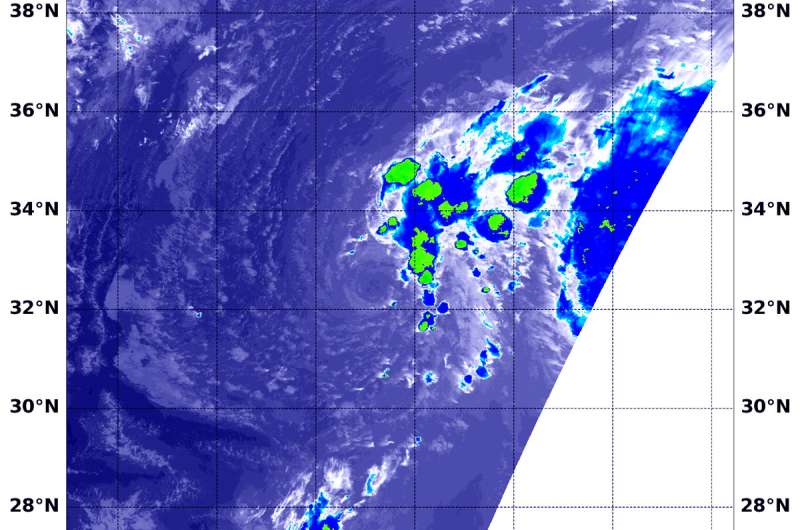
On Sept. 14, 2018 at 1:36 a.m. EDT (0536 UTC) the VIIRS instrument aboard NASA-NOAA's Suomi NPP satellite captured an infrared image of Tropical Storm Joyce. Coldest cloud top temperatures (yellow) of strongest thunderstorms were as cold as minus 50F/minus 45.5C, pushed northeast of the center. Credit: NOAA/NASA/NRL
NASA-NOAA's Suomi NPP satellite passed over the eastern Atlantic Ocean and saw that Tropical Storm Joyce is battling wind shear. Winds are pushing thunderstorm development northeast of the center.
Southwesterly shear continues to affect now Tropical Storm Joyce. In general, wind shear is a measure of how the speed and direction of winds change with altitude. Winds at different levels of the atmosphere pushed against the cylindrical circulation center and skewed it, weakening the rotation.
On Sept. 14 at 1:36 a.m. EDT (0536 UTC) the Visible Infrared Imaging Radiometer Suite (VIIRS) instrument aboard NASA-NOAA's Suomi NPP satellite captured an infrared image of Tropical Storm Joyce. VIIRS showed wind shear was tearing the storm apart. The coldest cloud top temperatures of strongest thunderstorms were as cold as minus 50 degrees Fahrenheit/minus 45.5 degrees Celsius and were northeast of the center.
The National Hurricane Center or NHC said "The system continues to produce bands of convection (developing thunderstorms) over the northeastern portion of the circulation, but the center remains exposed due to shear."
At 5 a.m. EDT (0900 UTC) the center of Tropical Storm Joyce was located near latitude 32.1 degrees north, longitude 44.9 degrees west. That's 1,090 miles (1,750 km) west-southwest of the Azores Islands. Joyce is moving toward the south-southwest near 8 mph (13 kph). Joyce is forecast to slow down and turn eastward by tonight, and then accelerate northeastward over the weekend.
Maximum sustained winds are near 40 mph (65 kph) with higher gusts. Little change in strength is forecast during the next couple of days.
Joyce is also close to Helene. In fact, Joyce is being steered in that direction around the larger circulation of Helene, located to its east-southeast. Once Helene passes east-northeast of Joyce later today, Joyce should turn eastward, then begin to accelerate northeastward over the weekend of Sept. 15 and 16.
Joyce is expected to weaken early next week.
Provided by NASA's Goddard Space Flight Center


