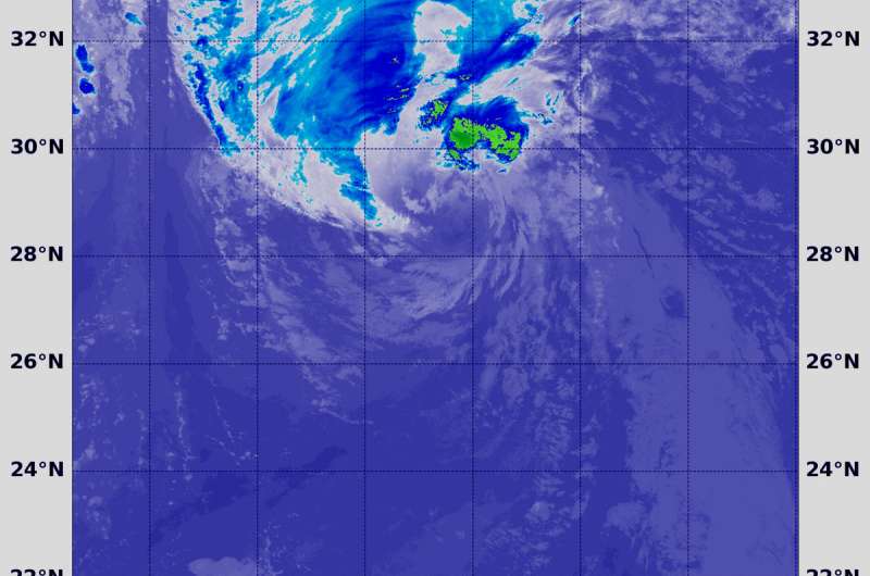
NASA-NOAA satellite find wind shear affecting Helene, Azores warnings up

Tropical Storm Helene may be battling wind shear but it's caused a Tropical Storm Warning for all of the Azores Islands on Sept. 15. NASA-NOAA's Suomi NPP satellite passed over the eastern Atlantic Ocean and analyzed the storm.
Southwesterly shear continues to affect now Tropical Storm Helene as it nears the Azores. In general, wind shear is a measure of how the speed and direction of winds change with altitude. Winds at different levels of the atmosphere pushed against the cylindrical circulation center and skewed it, weakening the rotation.
On Sept. 14 at 1:36 a.m. EDT (0536 UTC) the Visible Infrared Imaging Radiometer Suite (VIIRS) instrument aboard NASA-NOAA's Suomi NPP satellite captured an infrared image of Tropical Storm Helene. VIIRS showed wind shear was pushing all of the strongest storms northeast of center. In that quadrant of the storm, the coldest cloud top temperatures of strongest thunderstorms were as cold as minus 50 degrees Fahrenheit/minus 45.5 degrees Celsius.
The National Hurricane Center or NHC said "at 11 a.m. EDT (1500 UTC) the center of Tropical Storm Helene was located near latitude 32.9 degrees north and longitude 36.3 degrees west. Helene is moving toward the north near 23 mph (37 kph). A turn toward the north-northeast is forecast Saturday followed by a turn toward the northeast by Sunday night.
Satellite data indicate that maximum sustained winds have increased to near 70 mph (110 kph) with higher gusts. Little change in strength is forecast during the next 24 hours. Afterward, gradual weakening is expected over the weekend as Helene makes the transition to a post-tropical extratropical cyclone.
On the forecast track, Helene will pass near or over the Azores late Saturday, Sept. 15 or Sunday, Sept. 16.
Helene is expected to produce total rainfall amounts of 2 to 4 inches across the Azores, with isolated amounts up to 8 inches across the western Azores. This rainfall may cause life-threatening flash flooding. Ocean swells generated by Helene are affecting portions of the Azores. These swells are likely to cause life-threatening surf and rip current conditions.
Interests in the Ireland and United Kingdom should consult products from their local meteorological service for information about potential impacts from Helene in those locations.
Local forecasts and warnings for the U.K. can be found on the website of the UK Met Office at https://www.metoffice.gov.uk/.
Local forecasts and warnings for Ireland can be found on the website of Met Eireann at https://www.met.ie/.
For updated forecasts, visit: http://www.nhc.noaa.gov
Provided by NASA's Goddard Space Flight Center


