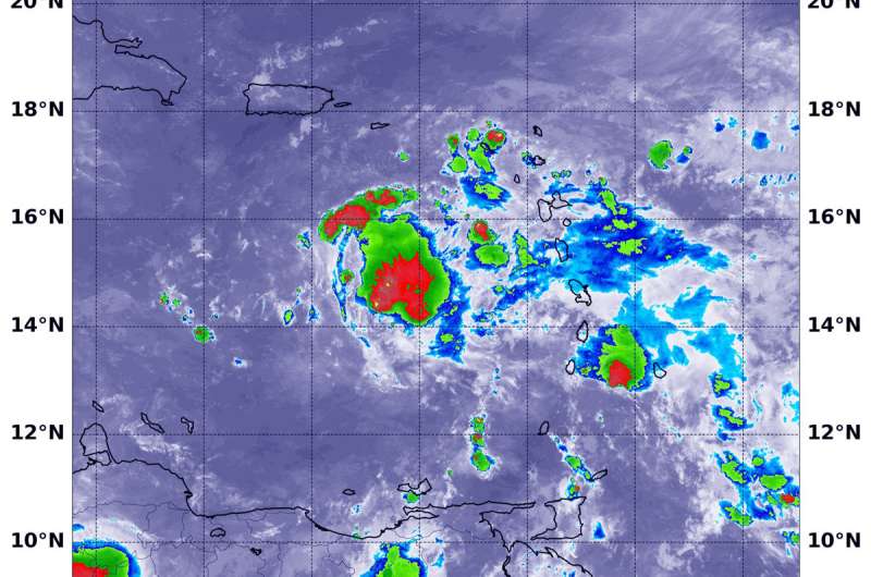
NASA-NOAA satellite finds winds tearing Tropical Depression Isaac apart

NASA-NOAA's Suomi NPP satellite passed over tropical cyclone Isaac in the eastern Caribbean Sea and it has weakened to a depression as a result of being hammered by vertical wind shear.
Northwesterly shear continues to take a toll on Isaac. In general, wind shear is a measure of how the speed and direction of winds change with altitude. Winds at different levels of the atmosphere pushed against the cylindrical circulation center and skewed it, weakening the rotation.
On Sept. 14 at 1:36 a.m. EDT (0536 UTC) the Visible Infrared Imaging Radiometer Suite (VIIRS) instrument aboard NASA-NOAA's Suomi NPP satellite captured an infrared image of Tropical Depression Isaac in the eastern Caribbean Sea. VIIRS showed wind shear was tearing the storm apart. The coldest cloud top temperatures of strongest thunderstorms were as cold as minus 70 degrees Fahrenheit/minus 56.6 degrees Celsius and were limited to one area of the storm.
The National Hurricane Center or NHC said "Although the system is still producing areas of deep convection, [satellite imagery] indicated that the circulation had become even less defined.
Moderate to strong northwesterly shear and dry mid-level air are likely to cause additional weakening, and Isaac is forecast to degenerate into an open wave within the next several days, but this could occur much sooner if the current trends continue."
At 5 a.m. EDT (0900 UTC), the center of Tropical Depression Isaac was located near latitude 15.0 degrees north and longitude 65.5 degrees west. That's about 190 miles (310 km) south-southwest of St. Croix. The depression is moving toward the west near 15 mph (24 kph), and this general motion with some decrease in forward speed is expected over the next few days. Maximum sustained winds have decreased to near 35 mph (55 kph) with higher gusts. Isaac is forecast to gradually weaken over the next few days, and could degenerate into a tropical wave at any time.
On the forecast track, Isaac will move over the eastern and central Caribbean Sea during the next few days.
Provided by NASA's Goddard Space Flight Center


