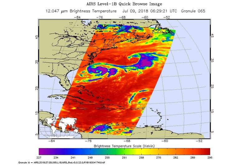
NASA's Aqua satellite passed over Tropical Storm Chris on July 9 at 2:29 a.m. EDT (0629 UTC) and saw coldest cloud top temperatures (purple) around the storm's center and in a thick band east of the center. Credit: NASA JPL/Heidar Thrastarson
Tropical Storm Chris was strengthening when NASA's Aqua satellite passed over the U.S. Eastern Seaboard on July 9. Aqua analyzed Tropical Storm Chris in infrared light.
Tropical Depression Three formed off the Carolina coast on Friday, July 6 around 5 p.m. EDT, about 230 miles (370 km) south-southeast of Cape Hatteras, North Carolina. The depression lingered off the Carolina coast over the weekend of July 7 and 8 and strengthened into a tropical storm on July 8 at 5 a.m. EDT.
NASA's Aqua satellite passed over Chris on July 9 at 2:29 a.m. EDT (0629 UTC) and analyzed the storm in infrared light. Infrared light provides temperature data and that's important when trying to understand how strong storms can be. The higher the cloud tops, the colder and the stronger they are.
AIRS found coldest cloud top temperatures around the storm's center and in a thick band east of the center. Northeast of Chris was a frontal boundary that also contained very cold cloud top temperatures. Those temperatures were as cold as minus 63 degrees Fahrenheit (minus 53 degrees Celsius). Storms with cloud top temperatures that cold have the capability to produce heavy rainfall.
The National Hurricane Center noted at 11 a.m. EDT (1500 UTC) that the center of Tropical Storm Chris was located near latitude 32.2 degrees north and longitude 74.5 degrees west. That's about 215 miles (345 km) south-southeast of Cape Hatteras, North Carolina. Chris has
been nearly stationary the past several hours, and little motion is expected during the next day or so and a northeastward motion is forecast to begin late Tuesday, and Chris is forecast to accelerate northeastward on Wednesday and Thursday.
Reports from a NOAA reconnaissance aircraft indicate that maximum sustained winds remain near 60 mph (95 kph) with higher gusts. The estimated minimum central pressure based on data from a NOAA reconnaissance aircraft is 999 millibars.
Strengthening is expected to begin by tonight and continue for the next couple of days, and Chris is forecast to become a hurricane on Tuesday, July 10.
Provided by NASA's Goddard Space Flight Center


