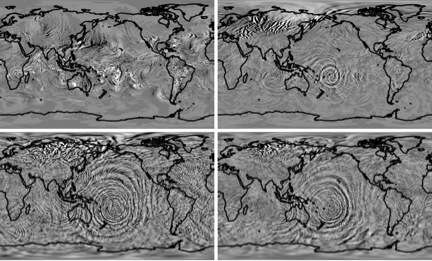
A model simulation illustrates how gravity waves kicked off by a cyclone east of Australia build as they travel toward space. The simulation was created using a high-resolution version of the Whole Atmosphere Community Climate Model (WACCM). Clockwise from upper left corner: Vertical winds at 11, 30, 87, and 100 km above Earth's surface. Credit: Hanli Liu, NCAR
Just as waves ripple across a pond when a tossed stone disturbs the water's surface, gravity waves ripple toward space from disturbances in the lower atmosphere.
Gravity waves are born when air masses are pushed up or down—by a thunderstorm, perhaps, or when wind is forced up and over a mountain range—but in the lower atmosphere, their impacts usually remain regional. By the time they reach the upper atmosphere, however, the waves have built in amplitude and extent. There, they can dominate atmospheric processes on a much larger scale, sometimes threatening the reliability of Earth-based communication systems.
For the first time, scientists have found a way to "watch" the propagation of gravity waves toward space—and the view is captivating. The trick, according to a team of researchers led by NCAR Senior Scientist Hanli Liu, was to push the NCAR-based Whole Atmosphere Community Climate Model to a resolution that is fine enough to pick up gravity waves at their source, when they're still relatively small.
"We've never seen a global picture of gravity waves in the upper atmosphere before, either from observations or simulations, even though we have suspected their importance up there," said Liu, who studies the upper atmosphere at NCAR's High Altitude Observatory. "This is the first time we have been able to capture these waves with a computer model of the whole atmosphere."
For the first time, scientists have simulated what gravity waves look like as they ripple upward through the atmosphere. This visualization, created on a supercomputer using a high-resolution version of the Whole Atmosphere Community Climate Model (WACCM), shows meridional (north-south) winds at two heights. The first segment shows winds at Earth's surface, where gravity waves usually have only regional impacts. The second segment shows winds at an elevation of 100 km (about 60 miles), where their influence can become dominant. The video simulations cover a three-day period when a hypothetical tropical cyclone was present off the east coast of Australia. Credit: UCAR. Simulations courtesy Hanli Liu, NCAR
The standard version of the model gets only a blurry look at phenomena that take place on scales less than 2,000 km (about 1,243 miles) across—and it's blind to anything smaller than 200 km. The higher-resolution model has much sharper vision all the way down to 200 km. The intense computing power of the NCAR-Wyoming Supercomputing Center's Yellowstone system made the higher-resolution runs possible.
In a study published in the journal Geophysical Research Letters, Liu and his colleagues demonstrated the finer-scaled model's abilities by showing how gravity waves such as those created by a tropical cyclone east of Australia grew as they traveled upwards. The model shows that what starts out as a localized phenomenon extends across the entire Pacific Region at 100 km above Earth's surface.
"For the middle and lower atmosphere, if you miss the gravity wave, you're not missing too much," Liu said. "But it's a different story in the upper atmosphere."
Disturbances in the upper atmosphere—which can endanger satellites, skew GPS readings, and shut down radio transmissions—are often thought about as originating from the Sun, where solar storms can kick off geomagnetic storms around Earth. But the ionosphere, the upper reaches of the atmosphere affected by this kind of space weather, is also influenced by disturbances originating on Earth.
These Earth-born disturbances can be difficult for scientists to disentangle when solar storm activity is strong, but the relative tranquility of the Sun during the last solar cycle has given scientists an opportunity to home in on the disturbances reaching the ionosphere from below, creating a fuller picture of processes in the ionosphere.
"When gravity waves propagate to the bottom side of the ionosphere, they can kick off instabilities," Liu said. "If you want to have a better understanding of space weather—the ionosphere—you need this kind of modeling capability."
More information: "Gravity waves simulated by high-resolution Whole Atmosphere Community Climate Model." Geophysical Research Letters DOI: 10.1002/2014GL062468
Journal information: Geophysical Research Letters
Provided by National Center for Atmospheric Research


