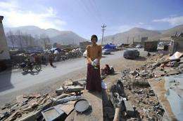
A Tibetan Buddhist monk puts on gloves as he cleans up rubble amid the earthquake devastation in Jiegu, Yushu county, in China's northwestern province of Qinghai.
Google released satellite imagery on Monday of the devastation from last week's earthquake which killed more than 2,000 people in northwest China.
The imagery, available on Google Earth, the Internet giant's online mapping product, included a before-and-after picture of a city heavily damaged by the 6.9-magnitude quake in Qinghai province on Wednesday.
Google said in a blog post that it had worked with satellite company GeoEye to obtain the high resolution post-earthquake pictures.
The Mountain View, California-based company also said "many of our Chinese Googlers" had helped to create a "Crisis Response" page for the earthquake.
Google's relations with China have been strained since the Internet giant announced in January that it had been the victim of China-based cyberattacks.
Google last month stopped censoring Web search results on its Chinese search engine and began redirecting users to an uncensored site in Hong Kong.
Google said the resources on the "Crisis Response" page include a "China Person Finder" tool that allows users to search for information about victims of the quake in Simplified Chinese, Traditional Chinese and English.
A "My Map" program allows users to contribute data about Qinghai including information about rescue efforts and conditions in specific areas, Google said.
Google said the Chinese version of the page can be accessed from a link on the homepages of google.com.hk and google.com.tw.
(c) 2010 AFP


