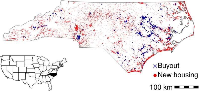
Construction of new housing in the floodplain far exceeded property buyouts in North Carolina over the last 2 decades. a) Time series of all residential construction, single-family homes, and buyouts per year. The y-axis represents the number of residential parcels either bought out or developed in each year. New construction was assigned to years based on the year built, and buyouts were assigned to years based on our best estimate of the completion date. Major hurricane events are represented by vertical lines. b) The share of residential construction in the floodplain increased from approximately 4% in the late 1990s up to 6% from 2011 through 2017. Credit: Journal of the American Planning Association (2023). DOI: 10.1080/01944363.2022.2141821
As extreme weather events become more often and intensify, the number of people and places exposed to flooding events is likely to grow.
But until now, surprisingly little was known about how floodplain development patterns vary across communities.
A new study from researchers at the University of North Carolina shows that new housing construction in flood-prone areas has contributed to increasing risk across NC despite community and government efforts to reduce flood damage. The study, published in the Journal of the American Planning Association, shows that more than ten new residences have been built in the state's 100-year floodplains for every residence removed through government buyouts (programs that purchase flood-prone property and restore it to open space).
"We've been putting more and more people in harm's way, and we see that pattern across the state—in coastal and inland communities, in urban and rural areas," said Miyuki Hino, an assistant professor in the Department of City and Regional Planning and a Faculty Fellow at the Carolina Population Center. "Communities across the state are working to reduce their flood risk through buyouts, elevating homes, and upgrading infrastructure, but it's harder to see those benefits when we're adding more houses and people to floodplains at the same time."
Hino and a team of researchers analyzed new construction across five million parcels in the State of North Carolina (U.S.) to develop standardized measures of floodplain development and evaluate the relationships between flood risk management effort and development outcomes.
"We find that community effort towards flood risk management doesn't always correspond to limiting floodplain development," said co-author Antonia Sebastian, Assistant Professor in the Department of Earth, Marine and Environmental Sciences (EMES). "Rather, communities rewarded by FEMA for high effort were continuing to allow more housing to be developed in the floodplain."
Local governments play a critical role in flood risk management. Knowing where communities are building in floodplains—and what measures can encourage growth in less hazardous areas—is important for reducing damages and risks.
"Strategic planning and zoning can encourage growth in safer areas and maximize open space in floodplains," said Hino. "As we see heavier downpours and wetter hurricanes, managing development is critical to reducing flood damages in the long term."
Another member of the team, Todd BenDor, the Distinguished Professor of Sustainable Community Design in the Department of City and Regional Planning and the UNC Institute for the Environment, noted that "we have long assumed that communities across the state have continued building in floodplains, at least to some extent. But, the sheer scale of this construction is really surprising, especially in that it dwarfs the large-scale efforts to move homes out floodplains and out of harm's way. The enormous public costs of buyouts are also shared by local governments—in many cases, the same local governments encouraging new building in floodplains. Today's new floodplain construction may be tomorrow's buyouts."
More information: Miyuki Hino et al, Growing Safely or Building Risk?, Journal of the American Planning Association (2023). DOI: 10.1080/01944363.2022.2141821
Provided by University of North Carolina at Chapel Hill


