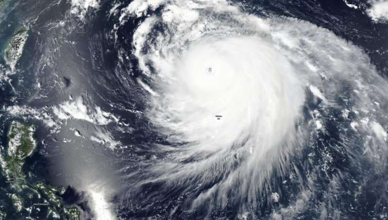
NASA-NOAA’s Suomi NPP satellite captured a visible image of Super Typhoon Haishen moving through the Philippine Sea on Sept. 4. Credit: NASA Worldview, Earth Observing System Data and Information System (EOSDIS)
NASA-NOAA's Suomi NPP satellite passed over the Philippine Sea on Sept. 4 and provided a visible image of Haishen that had strengthened into a super typhoon.
The Visible Infrared Imaging Radiometer Suite (VIIRS) instrument aboard Suomi NPP provided a visible image of Haishen that revealed a large, circular, organized structure of strong thunderstorms circling the open eye. The eyewall, the strong thunderstorms that circle the open eye, is estimated to be 81 nautical miles-wide. Satellite data indicate the eye is about 31 nautical miles wide. The storm is at least 450 miles in diameter, as tropical storm-force winds extend up to 225 miles from the center.
The Joint Typhoon Warning Center (JTWC) in Honolulu, Hawaii noted at 5 a.m. EDT (0900 UTC) on Sept. 4, that Super Typhoon Haishen had maximum sustained winds near 135 knots (155 mph/250 kph). It is currently a Category 4 hurricane/typhoon. It was centered near latitude 22.2 degrees north and longitude 134.3 degrees east, about 439 nautical miles southeast of Kadena Air Base, Okinawa Island, Japan. The storm was moving to the northwest.
JTWC forecasters expect Haishen will turn to the north-northwest while intensifying more. It is expected to peak later on Sept. 4 with sustained winds near 140 knots (161 mph/259 kph) which would make it equivalent to a Category 5 hurricane on the Saffir-Simpson Hurricane Wind Scale. JWTC forecasts Haishen to pass west of Kyushu, Japan and make landfall in South Korea after 3 days.
Provided by NASA's Goddard Space Flight Center


