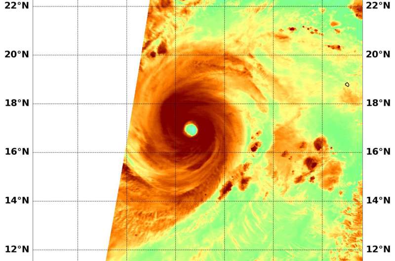
NASA's Aqua satellite passed over Hurricane Rosa in the Eastern Pacific Ocean on Sept. 28 at 4:55 a.m. EDT (855 UTC) and highest concentrations of water vapor (brown) and coldest cloud top temperatures were around the center. Credit: NASA/NRL
When NASA's Aqua satellite passed over the Eastern Pacific Ocean, water vapor data provided information about the intensity of Hurricane Rosa. On Sept. 28, Rosa is a major hurricane, now a Category 4 on the Saffir-Simpson Hurricane Wind Scale.
NASA's Aqua satellite passed Hurricane Rosa on Sept. 28 at 4:55 a.m. EDT (855 UTC) and the Moderate Resolution Imaging Spectroradiometer or MODIS instrument gathered water vapor content and temperature information. The MODIS image showed highest concentrations of water vapor and coldest cloud top temperatures were in a thick ring of storms around the 20 nautical mile-wide eye.
MODIS data also showed coldest cloud top temperatures were as cold as or colder than minus 70 degrees Fahrenheit (minus 56.6 degrees Celsius) in those storms. Storms with cloud top temperatures that cold have the capability to produce heavy rainfall.
Water vapor analysis of tropical cyclones tells forecasters how much potential a storm has to develop. Water vapor releases latent heat as it condenses into liquid. That liquid becomes clouds and thunderstorms that make up a tropical cyclone. Temperature is important when trying to understand how strong storms can be. The higher the cloud tops, the colder and the stronger they are.
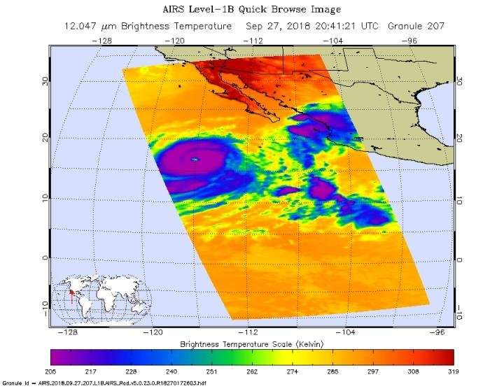
Twelve hours before the MODIS water vapor imagery, the Atmospheric Infrared Sounder instrument aboard NASA's Aqua satellite provided temperature data on the cloud tops on Sept. 27 at 4:41 p.m. EDT (2041 UTC). Coldest cloud top temperatures were as cold as or colder than minus 70 degrees Fahrenheit (minus 56.6 degrees Celsius) around the eye and confirmed the later MODIS data.
The Atmospheric Infrared Sounder instrument aboard NASA's Aqua satellite provided temperature data on the cloud tops of Category 4 Hurricane Rosa on Sept. 27 at 4:41 p.m. EDT (2041 UTC). Coldest cloud top temperatures were as cold as or colder than minus 70 degrees Fahrenheit (minus 56.6 degrees Celsius) around the eye and confirmed the MODIS data. Credit: NASA/JPL, Heidar Thrastarson
At 5 a.m. EDT (0900 UTC), the eye of Hurricane Rosa was located near latitude 16.9 degrees north and longitude 117.3 degrees west. That's 640 miles (1,030 km) southwest of the southern tip of Baja California, Mexico. Rosa is moving toward the west near 7 mph (11 kph). A gradual turn toward the west-northwest and northwest is expected on Friday, followed by a turn toward the north Saturday night and a turn toward the north-northeast on Sunday.
Maximum sustained winds are near 145 mph (230 kph) with higher gusts. Rosa is a category 4 hurricane on the Saffir-Simpson Hurricane Wind Scale. Little significant change in strength is forecast today, with gradual weakening anticipated by Saturday, and further weakening at a faster rate expected early next week.
NHC said although Rosa is not near the coast, swells generated by Rosa will affect portions of the coasts of southwestern Mexico, the southern Baja California Peninsula, and southern California late this week and over the weekend. These swells are likely to cause life-threatening surf and rip current conditions.
Provided by NASA's Goddard Space Flight Center


