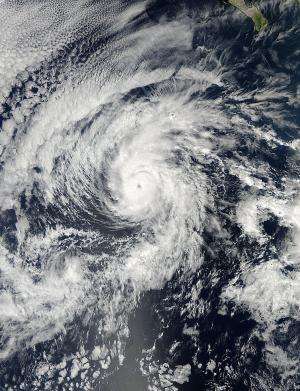
The MODIS instrument aboard NASA's Aqua satellite captured this visible image of Hurricane Raymond, re-strengthened in the Eastern Pacific. The image was taken on Oct. 27 at 21:15 UTC/5:15 p.m. EDT. Credit: NASA Goddard MODIS Rapid Response Team
Tropical Storm Raymond moved away from western Mexico and into warmer waters with less wind shear over the weekend of Oct. 26-27, where it strengthened into a hurricane again. NASA's Aqua satellite captured an eye-opening image of Raymond before it ran into strong wind shear.
The Moderate Resolution Imaging Spectroradiometer or MODIS instrument aboard NASA's Aqua satellite captured a visible image of Hurricane Raymond that showed its eye had re-developed and opened after it re-strengthened in the Eastern Pacific. The image was taken on Oct. 27 at 21:15 UTC/5:15 p.m. EDT.
By Oct. 28, wind shear had again kicked up again and Raymond was weakening. Wind shear increased from the southwest pushing the strongest convection, and showers and thunderstorms northeast of the center.
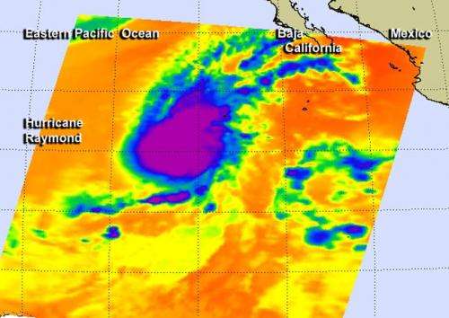
An infrared, false-colored image of Hurricane Raymond was taken by the Atmospheric Infrared Sounder or AIRS instrument aboard NASA's Aqua satellite on Oct. 28 at 9:23 UTC/5:23 a.m. EDT. The AIRS infrared image showed that the strongest storms had been displaced to the northeast of the center as a result of southwesterly wind shear. Those strong storms were still showing cold cloud top temperatures in excess of -63F/-52C indicating they were high in the troposphere and had the potential to generate heavy rain.
This infrared, false-colored image of Hurricane Raymond was taken by the AIRS instrument aboard NASA's Aqua satellite on Oct. 28 at 9:23 UTC/5:23 a.m. EDT and it showed that the strongest storms (purple) had been displaced to the northeast from wind shear. Credit: NASA/JPL, Ed Olsen
At 11 a.m. EDT/1500 UTC, Hurricane Raymond's maximum sustained winds were near 85 mph/140 kph and weakening. The center of Hurricane Raymond was near latitude 16.4 north and longitude 117.0 west, about 645 miles/1,035 km southwest of the southern tip of Mexico's Baja California. Raymond was moving toward the north near 7 mph/11 kph and is expected to turn toward the north-northeast. Raymond is forecast to weaken to a tropical storm late on Oct. 28 and a depression later that day.
The National Hurricane Center noted on Oct. 28 that Raymond is moving into an area with stronger wind shear, cooler sea surface temperatures and drier air: three factors that will lead to its dissipation in the next couple of days.
Provided by NASA's Goddard Space Flight Center


