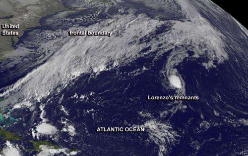
This GOES-East satellite image shows the remnants of Tropical Storm Lorenzo east of a frontal system in the central Atlantic Ocean. Credit: NASA GOES Project
Satellite imagery on Oct. 25 showed a cold front approaching the remnants of Tropical Storm Lorenzo in the central Atlantic Ocean.
A visible image captured by NOAA's GOES-East satellite image showed the oval-shaped remnants of Tropical Storm Lorenzo east of a frontal system in the central Atlantic Ocean. The image was created by NASA's GOES Project at the NASA Goddard Space Flight Center in Greenbelt, Md.
The National Hurricane Center noted that Lorenzo's remnants were generating disorganized showers and thunderstorms about 1,150 miles southwest of the Azores islands on Oct. 25. The remnant low pressure area is moving to the northeast at 10 mph, and environmental conditions are not expected to be cooperative to help Lorenzo regenerate. The National Hurricane Center gives Lorenzo's remnants a 20 percent chance to come back before it gets swallowed by the approaching cold front.
Provided by NASA's Goddard Space Flight Center


