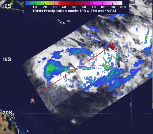
NASA's TRMM satellite captured a look at the rainfall rates within System 92P on March 7 at 0023 UTC (March 6 at 7:23 p.m. EST) hours before it became a tropical cyclone. Red areas indicate heavy rain, falling at a rate of 2 inches/50 mm per hour. Green and blue areas indicate moderate rainfall. Credit: NASA/SSAI, Hal Pierce
NASA's Tropical Rainfall Measuring Mission satellite noticed areas of heavy rainfall in low pressure System 92P hours before it became the nineteenth tropical cyclone of the Southern Pacific Ocean.
NASA's TRMM satellite captured a look at the rainfall rates within low pressure System 92P on March 7 at 0023 UTC (March 6 at 7:23 p.m. EST), just hours before it became Tropical Cyclone 19P (TC 19P). TRMM data indicated that heavy rain was falling at a rate of 2 inches/50 mm per hour around the center of circulation, and that some of the thunderstorms were powerful as they topped heights of 9.3 miles (15 kilometers). Bands of thunderstorms around the storm expanded, strengthened and wrapped tighter around the storm's center today, March 7, according to the Joint Typhoon Warning Center (JTWC).
On March 7 at 1200 UTC (7 a.m. EST) the intensifying tropical storm had maximum sustained winds near 35 knots (40 mph/64 kph). TC 19P was centered near 15.4 south latitude and 156.9 east longitude about 660 nautical miles (759.5 miles/1,222 km) northwest of Noumea, New Caledonia. TC19P was moving to the east-northeast at 11 knots (12.6 mph/20.3 kph).
JTWC forecasters expect TC 19P to strengthen and curve to the southeast, affecting New Caledonia by March 11.
Provided by NASA's Goddard Space Flight Center


