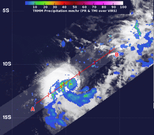
NASA sees strength in newborn Tropical Cyclone Emang

Tropical Cyclone Emang developed in the Southern Indian Ocean on Sunday, Jan. 13 about 525 nautical miles east-southeast of Diego Garcia. At that time, infrared satellite imagery revealed that the low level circulation center was partially exposed to outer winds, and there was a burst of thunderstorm development over the northwestern quadrant.
NASA's Tropical Rainfall Measuring Mission (TRMM) satellite captured rainfall rates in Tropical Storm Narelle on Jan. 13 at 0907 UTC (5:07 a.m. EST). Moderate and heavy rainfall was occurring around the center of circulation, where rainfall rates ranged from 30 mm (1.18 inches) to 50 mm (2 inches) per hour. That heavy rainfall is a sign that there is strong convection occurring within the storm, and forecasters at the Joint Typhoon Warning Center expect the storm will consolidate and organize more over the coming week.
On Monday, Jan. 14, at 0900 UTC (4 a.m. EST), Emang's maximum sustained winds were near 35 knots (40 mph/64.8 kph). Emang's center moved near 12.5 south latitude and 79.4 east longitude, about 500 nautical miles (575.4 miles/ 926 km) southeast of Diego Garcia. Emang was moving to the southwest at just 3 knots (3.4 mph/5.5 kph). Emang is located in is a weak steering environment. It is moving slowly under the influence of a building subtropical ridge (elongated area) of high pressure located to the south of the storm.
Monday's satellite data showed that the low-level center had now become fully exposed to outside winds, and there were shallow bands of thunderstorms around the northwestern edge of the storm. Emang is currently being battered with moderate (up to 20 knots/23 mph/37 kph) vertical wind shear.
Forecasters at the Joint Typhoon Warning Center expect improvements in environmental conditions which will improve the storm's organization. Emang is expected to slowly intensify over the next couple of days as it travels over open ocean. By the end of the week, Emang is expected to reach peak intensity as a cyclone of 65 knots (74.8 mph/120.4 kph).
Emang is currently not a threat to any land areas.
Provided by NASA's Goddard Space Flight Center


