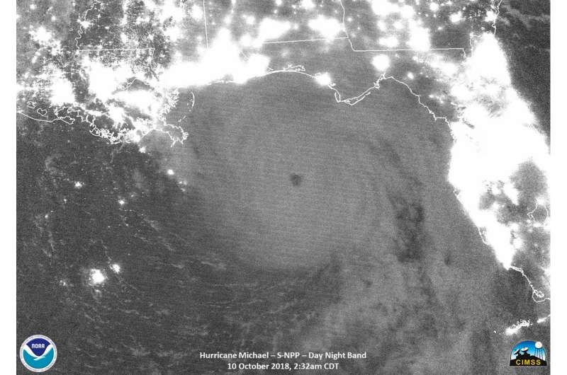
NASA-NOAA's Suomi NPP satellite obtained a night-time view of Hurricane Michael in the Gulf of Mexico on Oct. 10 at 0732 UTC (2:32 a.m. CDT). At the time, Michael was a Category 4 hurricane and the eye was so well-defined it could be seen clearly by moonlight. Lights from population centers along the Gulf coast appear white. Credit: NASA/NOAA/UW-SSEC-CIMSS, William Straka III
NASA-NOAA's Suomi NPP satellite examined Hurricane Michael after it reached Category 4 status and neared the Florida Panhandle on Oct. 10. Suomi NPP provided an infrared and night-time view of the powerful storm.
At 9 a.m. EDT on Oct. 10, water levels were quickly rising and winds increasing along the Florida panhandle as potentially catastrophic Michael approached.
Satellite Imagery Reveal
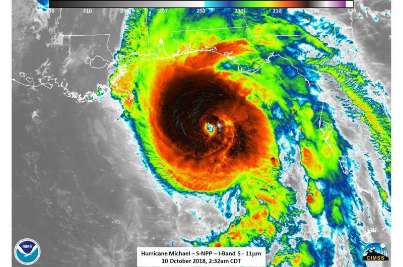
NASA-NOAA's Suomi NPP satellite obtained an infrared view of Hurricane Michael in the Gulf of Mexico on Oct. 10 at 0732 UTC (2:32 a.m. CDT). At the time, Michael was a Category 4 hurricane and the eye was so well-defined it could be seen clearly by moonlight. Infrared imagery revealed strong thunderstorms and tropospheric gravity waves in the northwest and western and eastern edges of the hurricane.
National Hurricane Center forecaster Daniel Brown described Hurricane Michael in visible and infrared imagery, "Michael is an extremely impressive hurricane in visible and infrared satellite imagery this morning. The eye has continued to warm and become even more distinct, while remaining embedded within an area of very cold cloud tops."
Many Warnings and Watches in Effect
NOAA's National Hurricane Center has noted many warnings and watches in effect.
NASA-NOAA's Suomi NPP satellite obtained an infrared view of Hurricane Michael in the Gulf of Mexico on Oct. 10 at 0732 UTC (2:32 a.m. CDT). At the time, Michael was a Category 4 hurricane and the image revealed strong thunderstorms and tropospheric gravity waves in the northwest and western and eastern edges of the hurricane. Credit: NASA/NOAA/UW-SSEC-CIMSS, William Straka III
A Storm Surge Warning is in effect for Okaloosa/Walton County Line, Florida to Anclote River, Florida. A Storm Surge Watch is in effect from Anclote River, Florida to Anna Maria Island Florida, including Tampa Bay. A Hurricane Warning is in effect from the Alabama/Florida border to Suwannee River, Florida. A Tropical Storm Warning is in effect from the Alabama/Florida border to the Mississippi/Alabama border and from Suwanee River Florida to Chassahowitzka, Florida and north of Fernandina Beach, Florida to Surf City, North Carolina. A Tropical Storm Watch is in effect from Chassahowitzka to Anna Maria Island, Florida, including Tampa Bay; from the Mississippi/Alabama border to the Mouth of the Pearl River; from Surf City, North Carolina to Duck, North Carolina, and for the Pamlico and Albemarle Sounds.
Status of Michael at 11 a.m. EDT on Wednesday, October 10, 2018
NOAA's National Hurricane Center reported at 11 a.m. EDT (1500 UTC), the eye of Hurricane Michael was located near latitude 29.4 degrees north and longitude 86.0 degrees west.
Michael is moving toward the north-northeast near 14 mph (22 kph). A turn toward the northeast is expected this afternoon or tonight. A motion toward the northeast at a faster forward speed is forecast on Thursday through Friday night. On the forecast track, the core of Michael is expected to move ashore along the Florida Panhandle early this afternoon, move northeastward across the southeastern United States tonight and Thursday, and then move off the Mid-Atlantic coast away from the United States on Friday, Oct 12.
Data from NOAA and Air Force Reserve Hurricane Hunter aircraft indicate that maximum sustained winds are near 145 mph (230 kph) with higher gusts. Michael is an extremely dangerous category 4 hurricane on the Saffir-Simpson Hurricane Wind Scale. Some strengthening is still possible before landfall. After landfall, Michael should weaken as it crosses the southeastern United States. Michael is forecast to become a post-tropical cyclone on Friday, and strengthening is forecast as the system moves over the western Atlantic.
Hurricane-force winds extend outward up to 45 miles (75 km) from the center and tropical-storm-force winds extend outward up to 175 miles (280 km). A private weather station at Bald Point, Florida, recently reported a sustained wind of 54 mph (87 kph) with a gust to 61 mph (98 kph). A wind gust to 46 mph (74 kph) was recently reported inland at Tallahassee, Florida. The latest minimum central pressure based on data from the reconnaissance aircraft is 928 millibars.
Provided by NASA's Goddard Space Flight Center


