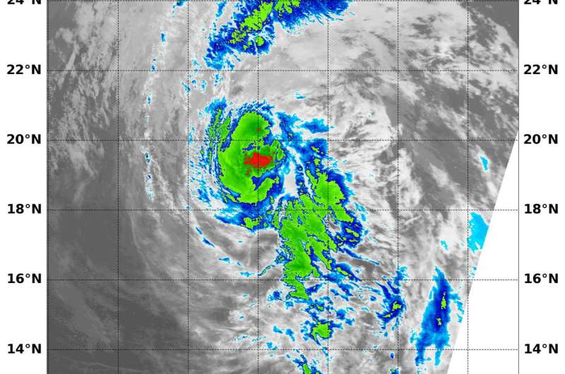
NASA's Aqua satellite passed over Fabio on July 5 at 6:15 a.m. EDT (1015 UTC) and revealed one small area of strong thunderstorms (red) where cloud top temperatures as cold or colder than minus 70 degrees Fahrenheit (minus 56.6 degrees Celsius). Credit: NASA/NRL
Infrared imagery from NASA revealed that only one small area of storms remained in Tropical Storm Fabio.
NASA's Aqua satellite passed over Fabio on July 5 at 6:15 a.m. EDT (1015 UTC) and analyzed the storm in infrared light. The MODIS or Moderate Resolution Imaging Spectroradiometer instrument aboard NASA's Aqua satellite revealed revealed one small area of strong thunderstorms where cloud top temperatures as cold or colder than minus 70 degrees Fahrenheit (minus 56.6 degrees Celsius). Cloud tops with temperatures that cold have the potential to generate very heavy rainfall.
At 11 a.m. EDT (1500 UTC), the National Hurricane Center (NHC) said Fabio's convective structure has continued to degrade over the past several hours, and convective banding has become very limited.
The center of Tropical Storm Fabio was located near latitude 20.2 degrees north and longitude 125.4 degrees west. Fabio was moving toward the northwest near 17 mph (28 kph). A west-northwestward to northwestward motion at a similar forward speed is expected today. Fabio is then forecast to slow down and move west-northwestward through the weekend.
Maximum sustained winds have decreased to near 65 mph (100 kph) with higher gusts. Additional weakening is likely, and the NHC said Fabio is forecast to become a remnant low in a day or two.
Provided by NASA's Goddard Space Flight Center


