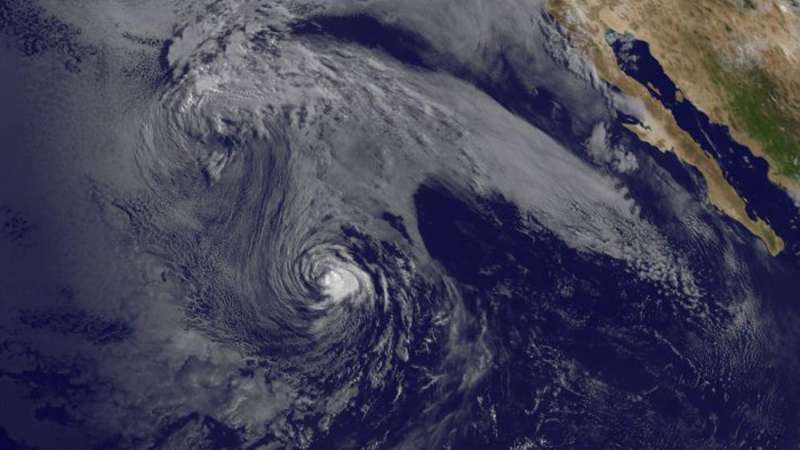
At 11:00 a.m. EDT (1500 UTC) NOAA's GOES-West satellite captured a visible image of Tropical Storm Irwin in the Eastern Pacific Ocean. Credit: NASA/NOAA GOES Project
Satellite imagery from NOAA's GOES-West satellite showed two areas of circulation in the Eastern Pacific Ocean. One of the areas was the remnant circulation from former Tropical Storm Hilary and the other was Tropical Storm Irwin, located southeast of Hilary.
At 11:00 a.m. EDT (1500 UTC) NOAA's GOES-West satellite captured a visible image of Tropical Storm Irwin and Hilary's remnant circulation center. The National Hurricane Center noted that although the structure of Irwin remains well organized, deep convection and thunderstorm development has been on the decline during the morning hours on July 31 due to the influences of cool, 24 degree Celsius (75 degrees Fahrenheit) water and dry air.
NOAA manages the GOES series of satellites. NASA/NOAA's GOES Project at NASA's Goddard Space Flight Center in Greenbelt, Maryland uses the satellite data to create imagery.
At that time, the center of Tropical Storm Irwin was located near 21.9 degrees north latitude and 127.3 degrees west longitude. That's about 1,110 miles (1,790 km) west of the southern tip of Baja California, Mexico. Irwin was moving toward the north-northwest near 14 mph (22 kph) and this motion is expected to continue today. A slower motion toward the northwest should begin on Tuesday. Maximum sustained winds have decreased to near 50 mph (85 kph) with higher gusts.
Irwin is moving north-northwestward in the wake of Post-Tropical cyclone Hilary, and this motion is expected to continue for about another day.
Irwin is expected to continue weakening, and it is forecast to degenerate into a remnant low tonight or early Tuesday, August 1.
Provided by NASA's Goddard Space Flight Center


