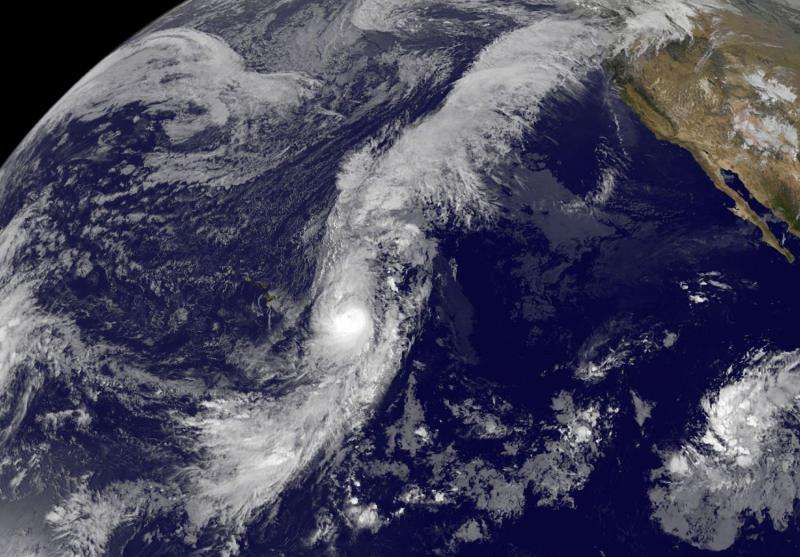
On Oct. 7, NOAA's GOES-West satellite captured this infrared view of Tropical Storm Oho and its extensive flow northeast toward Canada. Credit: NASA/NOAA GOES Project
Hurricane Oho appears to have extremely long arms in imagery from NOAA's GOES-West satellite on October 7. Moisture from Oho is being drawn along a stationary front to Oho's northeast, making it appear as if Oho is pointing toward southwestern Canada.
On October 7, Oho was located east of Hawaii, but outflow of clouds from the center streamed northeast along a frontal boundary all the way to southeastern Canada. The boundary is connected to a low pressure area in the Eastern Pacific Ocean, centered hundreds of miles west of southwestern Canada.
NOAA's Central Pacific Hurricane Center (CPHC) said that Oho continued to have an eye in infrared satellite imagery early on October 7, however, the storm likely reached the peak of the Intensification since infrared data such as that from the AIRS instrument aboard NASA's Aqua satellite have shown that the cold cloud tops surrounding the eye are warming. Warming cloud tops indicate they are dropping in altitude, and that means there is less uplift in the air - which is a sign the storm is weakening.
Oho appeared elongated from north to south in an infrared image from NOAA's GOES-West satellite on October 7. The image was created by the NASA/NOAA GOES Project at NASA's Goddard Space Flight Center in Greenbelt, Maryland.
At 5 a.m. HST/11 a.m. EDT/1500 UTC on October 7, the center of hurricane oho was located near latitude 23.5 north and longitude 145.9 west. That's about 645 miles (1,040 km) east-northeast of Hilo, Hawaii. Oho was moving toward the north-northeast near 35 mph (56 kph). Oho is expected to continue accelerating toward the north-northeast during the next couple of days. Maximum sustained winds are near 110 mph. (175 kph) and is expected to weaken.
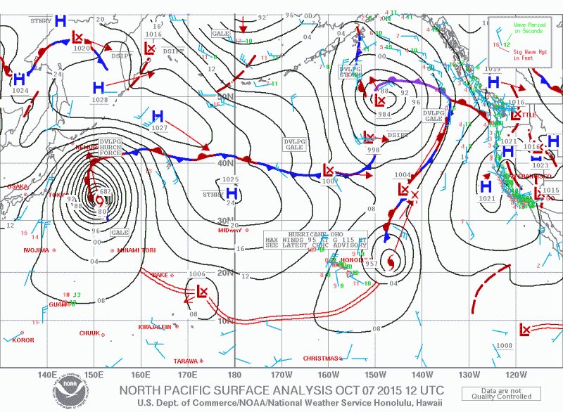
This North Pacific Surface Analysis of the Central and Eastern Pacific Ocean shows the position of Hurricane Oho and a low pressure area to its northeast creating the moisture plume to Oho's northeast. Generated from the Unified Surface Analysis. Credit: NWS/Hawaii
Oho is currently over sea surface temperatures of around 26 Celsius (78.8 Fahrenheit). Tropical cyclones like Oho require sea surface temperatures of at least 26.6C (80F) to maintain intensity. Cooler waters will weaken a tropical system and the latest forecast track takes the hurricane across cooler waters.
Forecaster Houston at NOAA's CPHC said that Oho is forecast to gradually weaken during the next 24 hours. More rapid weakening is anticipated beyond 24 hours and Oho is expected to become extra-tropical by October 7 as it speeds to the northeast and Canada.
For updated forecasts from NOAA's CPHC, visit: http://www.prh.noaa.gov/cphc.
Provided by NASA's Goddard Space Flight Center


