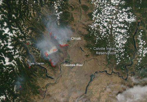
The natural-color image above was taken on July 21, 2014 by the Moderate Resolution Imaging Spectroradiometer, MODIS, instrument on July 21, 2014 aboard the NASA's Aqua satellite. Actively burning areas, detected by MODIS's thermal bands, are outlined in red. Credit: Jeff Schmaltz LANCE/EOSDIS MODIS Rapid Response Team, GSFC.
The Carlton Complex fires started on July 14, 2014, by lightning from a weather system that moved through the Methow Valley.
The Carlton Complex consists of four fires: Stokes Fire, Gold Hikes Fire, French Creek Fire and the Cougar Flat. The Stokes and Gold Hikes fires are now one larger fire. The fires are burning in timber and grass and the area burning is currently over 243,000 acres in size. The present fire situation continues to rapidly change due to the highfire danger. Public and firefighter safety is the priority on the Carlton Complex fires. Thirty-five primary residences were lost in the fire through the night of July 21.
Hot weather and windy conditions pushed the fire over the ridge tops and into the town of Pateros resulting in a large number of evacuations. An estimated 300-500 homes were evacuated, including the Pateros Red Cross shelter. There are now over 2,100 personnel working on this fire with more personnel coming in to fight the fire.
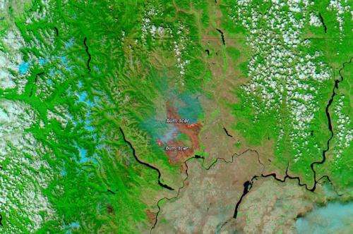
The natural-color image above was taken on July 21, 2014 by the Moderate Resolution Imaging Spectroradiometer, MODIS, instrument on July 21, 2014 aboard the NASA's Aqua satellite. Actively burning areas, detected by MODIS's thermal bands, are outlined in red. If you click on the image, another image will appear showing the current burn scars from the fire. This false-color image was taken by MODIS instrument on the Aqua satellite on July 21, 2014.
This image shows the current burn scars from the fire. This false-color image was taken by MODIS instrument on the Aqua satellite on July 21, 2014. Credit: Jeff Schmaltz LANCE/EOSDIS MODIS Rapid Response Team, GSFC.
Provided by NASA's Goddard Space Flight Center


