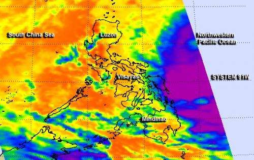
NASA's Aqua satellite captured an infrared image of System 91W on Jan. 16 at 12:23 a.m. EST showing high, cold cloud top temperatures (purple) in the western quadrant. Credit: NASA JPL, Ed Olsen
The tropical low pressure area known as System 91W that has been plaguing the central and southern Philippines for the last couple of days continues to bring floods and heavy rainfall today, January 16. NASA's Aqua satellite passed over System 91W and identified powerful thunderstorms with the potential for heavy rainfall, moving back toward the Visayas and Mindanao regions.
The Atmospheric Infrared Sounder or AIRS instrument aboard Aqua captured an infrared image of System 91W on Jan. 16 at 05:23 UTC/12:23 a.m. EST that shows high, cold cloud top temperatures, colder than -63F/-52C in the western quadrant of the low pressure area. The storm dropped heavy rains and caused flooding and landslides in the last couple of days in the central region of Visayas and southern region of Mindanao, Philippines, then moved east, back over the Northwestern Pacific Ocean. Today, System 91W is moving in a southwesterly direction and back toward Mindanao.
On January 16, the National Disaster Risk Reduction and Management Council (NDRRMC) of Quezon City, Philippines noted there were 13 landslide incidents and 6 flood/flash flooding incidents. The heavy rains have caused 31 deaths and 36 injuries. In addition 7 people were still missing. NDRRMC noted that more than 376,000 people have been affected.
On January 16 at 1500 UTC/10 a.m. EST, System 91W was centered near 9.4 north latitude and 127.7 east longitude, about 370 nautical miles east-northeast of Zamboanga, Philippines.
The Joint Typhoon Warning Center or JTWC gives System 91W a high chance for becoming a tropical depression in the next 24 hours.
The JTWC noted that a recent microwave satellite image showed that the low-level center of the system is consolidating and organizing. Convection (rising air that forms thunderstorms) is fragmented in the northern quadrant of the system. Sea surface temperatures are warm enough to assist in developing the low into a tropical depression, according to JTWC.
Forecasters at JTWC noted that dynamic computer model guidance is weakly developing System 91Was it drifts towards Mindanao. Residents in the Mindanao and Visayas regions should be in guard for more heavy rainfall, flash flooding and mudslides.
More information: For the latest information and local forecasts, visit: http://www.ndrrmc.gov.ph/
Provided by NASA's Goddard Space Flight Center


