The AIRS instrument aboard NASA's Aqua satellite captured infrared data on Tropical Depression 29W on Oct. 29 at 04:23 UTC/12:23 a.m. EDT and saw strong thunderstorms (purple) west and east of the center. Credit: NASA JPL, Ed Olsen
Satellite data showed some recent convective activity within Tropical Storm Raymond on Oct. 28 but southwesterly wind shear and cooler ocean temperatures are predicted by the National Hurricane Center to weaken the tropical storm to a remnant low on Wednesday October 30, 2013.
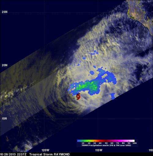
Raymond contained rainfall only in an area northwest of its center of circulation when the Tropical Rainfall Measuring Mission or TRMM satellite passed above on October 28, 2013 at 2337 UTC/4:37 p.m. PDT. Rainfall data from TRMM's Microwave Imager (TMI) and Precipitation Radar (PR) were combined with a visible and infrared image from TRMM's Visible and InfraRed Scanner (VIRS) to provide an analysis of the storm. The analysis revealed that the maximum rainfall intensity associated with Raymond was only about 33.6mm/~1.3 inches per hour. The TRMM satellite is managed by NASA and JAXA.
The National Hurricane Center noted that Tropical Storm Raymond's maximum sustained winds were down to near 50 mph/85 kph on Oct. 29 at 11 a.m. EDT/1500 UTC. Raymond's center was located near latitude 18.3 north and longitude 116.9 west, about 555 miles/890 km southwest of the southern tip of Baja California, Mexico. Raymond was moving slowly at 6 mph/9 kph, and is expected to slow more as it weakens over cooler waters tonight, Oct. 29. The NHC expects Raymond to become a remnant low in a day or so.
Provided by NASA's Goddard Space Flight Center


