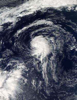
NASA's Aqua satellite captured this image of Tropical Depression 13L in the Atlantic on Oct. 21 at 16:55 UTC/12:55 p.m. EDT, before it became Tropical Storm Lorenzo. Credit: NASA Goddard MODIS Rapid Response Team
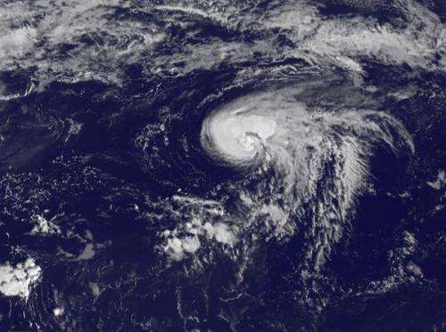
It took six hours for the thirteenth tropical depression of the Atlantic Ocean hurricane season to organize and strengthen into Tropical Storm Lorenzo. NASA's Aqua satellite captured a "before" image and NOAA's GOES satellite captured an "after" image of the depression's transition.
Lorenzo was born on Oct. 21 at 11 a.m. as Tropical Depression 13L. By 5 p.m. EDT it had strengthened into Tropical Storm Lorenzo. Lorenzo is also the twelfth tropical storm of the Atlantic Ocean Hurricane Season, which means that just one depression did not reach tropical storm strength so far this year.
The Moderate Resolution Imaging Spectroradiometer known as the MODIS instrument aboard NASA's Aqua satellite captured a visible image of Tropical Depression 13L in the Atlantic on Oct. 21 at 16:55 UTC/12:55 p.m. EDT before it became Tropical Storm Lorenzo. The visible image showed the bulk of the depressions thunderstorms and clouds were in the eastern and northern quadrants of the storm.
NOAA's GOES-East satellite captured a visible image of Tropical Storm Lorenzo on Oct. 22 at 1145 UTC/7:45 a.m. EDT as it continued strengthening in the central Atlantic Ocean. The GOES image showed that the bulk of clouds and showers had shifted to the north and west of the storm's center. In the GOES image, Lorenzo's strongest thunderstorms look almost like a horseshoe.
On Oct. 22 at 11 a.m. EDT/1500 UTC Lorenzo's maximum sustained winds had increased to near 50 mph/85 kph and the National Hurricane Center expects little change in strength, followed by a weakening trend on Oct. 23. Those tropical storm force winds extend outward up to 70 miles/110 km from Lorenzo's center.
NOAA's GOES-East satellite captured this visible image of Tropical Storm Lorenzo on Oct. 22 at 1145 UTC/7:45 a.m. EDT as it continued strengthening in the central Atlantic Ocean. Credit: NASA GOES Project
Lorenzo's center was located far from land areas. It was near latitude 29.5 north and longitude 52.0 west, about 785 miles/1,260 km east of Bermuda. Lorenzo was moving toward the east-northeast near 8 mph/13 kph. The estimated minimum central pressure is 1003 millibars.
Forecasters at the National Hurricane Center (NHC) expect that Lorenzo is going to experience stronger wind shear from the northwest as it moves further northeast into cooler waters. Both of those factors are expected to take a toll on the storm and weaken it. By Oct. 25, Lorenzo is expected to become an elongated area of low pressure, a trough, ahead of an approaching cold front.
Provided by NASA's Goddard Space Flight Center


