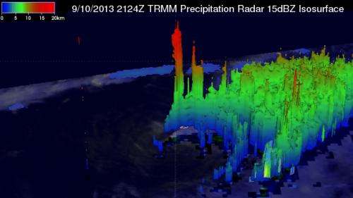
This 3-D image of Tropical Storm Gabrielle's rainfall was created by data from NASA's TRMM satellite, and clearly shows wind shear had pushed all the rainfall east of center. Credit: SSAI/NASA, Hal Pierce
Data obtained from NASA's TRMM satellite was used to create a 3-D image of Tropical Storm Gabrielle's rainfall that clearly showed wind shear pushed all of the storm's the rainfall east of its center.
NASA's Tropical Rainfall Measuring Mission satellite known as "TRMM" flew directly above tropical Storm Gabrielle on September 10, 2013 at 2124 UTC (5:24 p.m. EDT) as the storm approached Bermuda. TRMM's Precipitation Radar (PR) data found that rain was falling at a rate of over 127mm/~5 inches per hour in a line of intense storms southeast of Bermuda. TRMM PR also found that the tallest thunderstorms, reaching to heights above 15.5km (~9.6 miles), were located in an area close to Gabrielle's center of circulation.
Wind shear was affecting Gabrielle on Sept. 10 and continued to affect the storm on Sept. 11. Winds are blowing from the southwest at 15 to 20 knots and pushing the clouds and rain associated with Gabrielle to the northeast of the center. On Sept. 11, tropical storm force winds extend outward up to 115 miles/185 km, and because of wind shear, those strong winds were mostly northeast of the center.
Wind shear is basically any change in wind speed or direction along a straight line. In reference to tropical cyclones it means winds vertically from the ocean surface to top of the troposphere. Wind shear removes the heat and moisture that tropical cyclones require around their center of circulation and it will elongate the storm. When a storm elongates, basically the top is blown away from the bottom part of the storm, tilting the circulation center (think of tilting a tire at a 45 degree angle for example). Whenever the center tilts, it can't rotate as easily, and it's a less-efficient heat engine, so winds coming in at the low levels and flowing out at the upper levels get disrupted, generally causing the storm to weaken.
NASA's TRMM satellite data was used to create this animation of Tropical Storm Gabrielle's rainfall and cloud heights on Sept. 10. Rain was falling at a rate of over 127mm/~5 inches per hour in parts of Gabrielle and the tallest thunderstorms, reaching to heights above 15.5km (~9.6 miles). Credit: SSAI/NASA, Hal Pierce
Although Bermuda's watches and warnings have been dropped, Gabrielle is still expected to bring between 1 and 3 inches of rainfall to the island today. Tropical-storm force winds will wane early on Sept. 11, but rough surf is expected to continue as Gabrielle pulls away.
At 8 a.m. EDT/1200 UTC, Gabrielle's maximum sustained winds were near 50 mph/85 kph and weakening is forecast during the next 48 hours. The center of Tropical Storm Gabrielle was located near latitude 32.4 north and longitude 65.7 west. At that time, Gabrielle was stationary but is expected to start moving slowly to the northwest then turn north on Sept. 12. At 8 a.m. EDT an elevated station at Commissioners Point on Bermuda reported a wind gust of 47 mph/76 kph.
The National Hurricane Center noted that over the next two to three days, whatever is left of Gabrielle is expected to merge with a frontal system moving east.
Provided by NASA's Goddard Space Flight Center


