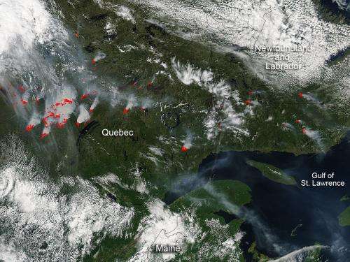
Credit: NASA image courtesy Jeff Schmaltz, MODIS Rapid Response Team.
Fires around James Bay continue raging in Canada due to the driest summer the region has seen in 40 years as seen in this Aqua satellite photo from July 09, 2013. These fires have been raging for several weeks now and are also causing other problems besides burning land and causing pollution. About 10 per cent of Quebecers lost electricity on July 5, on the second day of blackouts triggered by the powerful forest fires.
Hydro-Quebec said 500,000 households or businesses were affected at the peak of the blackout. Apparently the smoke from forest fires had prompted a major transmission line to seize up near James Bay. Smoke from the fires coming across electrical lines ionizes the air which in turn caused the line to seize up and trigger the blackouts. This initial failure cascaded to other lines as well. Even Montreal's subway system was shut down for a time last Wednesday the 4th.
Quebec provincial teams were battling a number of blazes, with help from Parks Canada. More than 280,000 hectares (1081 square miles) of forested area have been scorched. Three major forest fires are being monitored—including the biggest one, which has raged at speeds of up to 30 kilometres per hour (18.6 miles per hour).
This natural-color satellite image was collected by the Moderate Resolution Imaging Spectroradiometer (MODIS) aboard the Aqua satellite on July 09, 2013. A May 25 thunderstorm ignited the series of fires which have been burning ever since. Actively burning areas, detected by MODIS's thermal bands, are outlined in red.
Provided by NASA's Goddard Space Flight Center


