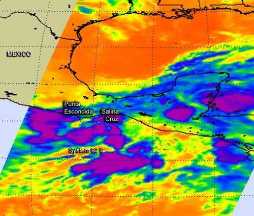
NASA's Aqua satellite flew over System 92E in the eastern Pacific Ocean on May 28 at 07:17 UTC (3:17 a.m. EDT) and captured this infrared image of the storm. The purple areas indicate the coldest cloud top temperatures and strongest storms. Credit: NASA JPL, Ed Olsen
NASA's Aqua satellite captured an image of System 92E, a tropical low pressure area that is ripe for development into a tropical depression and tropical storm, as it continues to develop near to southwestern Mexico.
System 92E may organize more and become Tropical Storm Barbara later on May 28 as it continues organizing near the southwestern Mexican coast. When NASA's Aqua satellite flew over System 92E on May 28 at 07:17 UTC (3:17 a.m. EDT), the Atmospheric Infrared Sounder (AIRS) instrument aboard Aqua captured an infrared image of the storm. AIRS measured cloud top temperatures as cold as -63 Fahrenheit (-52 Celsius), that were indicative of high, strong thunderstorms with the potential to drop heavy rain. Those storms stretched over open waters west of Punta Escondida southward to Salina Cruz.
System 92E appears almost stationary, and the National Hurricane Center (NHC) expects the low to continue consolidating. Shower and thunderstorm activity continues to gradually increase today, May 28. System 92E's center is about 200 miles south of Salina Cruz, Mexico.
The NHC expects System 92E to become Tropical Storm Barbara late in the day on May 28, before it makes landfall later along the southwestern coast of Mexico. Tropical Storm Warnings could be posted later in the day and heavy rains are expected over southern Mexico and western Central America during the next few days.
Provided by NASA's Goddard Space Flight Center


