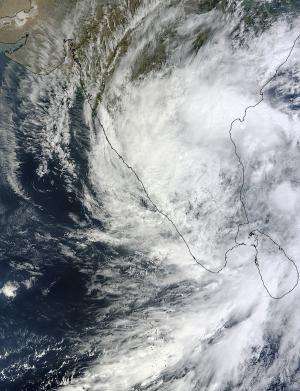
The MODIS instrument that flies aboard NASA's Terra satellite captured this visible image of Tropical Cyclone Nilam over southern India on Nov. 1 at 05:50 UTC (1:50 a.m. EDT). Credit: NASA Goddard MODIS Rapid Response Team
After Tropical Cyclone Nilam made landfall in southeastern India NASA's Terra satellite passed overhead and saw the storm's clouds blanket the entire southern portion of the country from Chennai southward.
On Nov. 1 at 05:50 UTC (1:50 a.m. EDT), the Moderate Resolution Imaging Spectroradiometer (MODIS) instrument that flies aboard NASA's Terra satellite captured a visible image of Tropical Depression Nilam.
The MODIS image showed that Nilam's clouds stretched as far north as Andra Pradesh, a state in east central India. It covered the states of Goa and Karnataka in the west, all the way down to the states of Tamil Nadu, Puducherry and Kerala in extreme southern India.
On Oct. 31 at 1500 UTC (11 a.m. EDT/8:30 p.m. local time, India), Nilam made landfall over southeastern India and started to elongate. When a system is no longer circular and starts to elongate, it begins to weaken.
India's Regional Specialised Meteorological Centre (RSMC) issued a bulletin on Tropical Depression Nilam on Nov. 1 at 2 a.m. EDT (11:30 a.m. local time/India). At that time, Nilam was centered over Rayalaseema. Rayalaseema is a geographic region in the state of Andhra Pradesh. The RSMC noted that Nilam is expected to move northwestward and weaken to a remnant low pressure area later on Nov. 1.
The RSMC expects heavy rainfall over Rayalaseema, Karnataka and south coastal Andhra Pradesh and north Tamilnadu on Nov. 1 and Nov. 2 before the storm dissipates.
Provided by NASA's Goddard Space Flight Center


