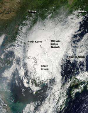
NASA's Aqua satellite's MODIS instrument captured this visible, true-color image of Tropical Storm Tembin at the time of landfall in southwestern South Korea. The image was captured at 04:45 UTC (12:45 am EDT) on Aug. 30. Credit: NASA Goddard /MODIS Rapid Response Team
Tropical Storm Tembin made landfall in the in southwestern South Korea and NASA's Aqua satellite captured the extent of the storm's elongated cloud cover, revealing the effect of wind shear on the storm.
Tembin moved through the Myeongnyang Strait and made landfall on Aug. 30, 2012 at 0000 UTC (Aug. 29 at 8 p.m. EDT) in the southwestern tip of South Korea.
NASA's Aqua satellite's Moderate Resolution Imaging Spectroradiometer (MODIS) instrument captured a visible, true-color image of Tropical Storm Tembin around the time of landfall in southwestern South Korea. The image was captured at 04:45 UTC (12:45 a.m. EDT) on Aug. 30, and showed an elongated storm stretching from southwestern South Korea, over North Korea and into the Sea of Japan. Southwesterly wind shear has also taken its toll on Tembin as the storm has become elongated. When a storm is no longer circular, it loses its energy.
Satellite imagery also revealed that central convection (rising air that forms thunderstorms that make up Tembin) have been decaying rapidly.
On Aug. 30 at 0300 UTC (Aug. 29 at 11 p.m. EDT) Tropical Storm Tembin's maximum sustained winds were near 35 knots (40 mph/65 kmh). It was located about 85 nautical miles (97.8 miles/157.4 km) south of Kunsan Air Base, South Korea, near 35.5 North and 127.2 East. Tembin is moving to the north-northeast at 23 knots (26.4 mph/42.6 kmh) and forecasters at the Joint Typhoon Warning Center expect the storm to continue accelerating and drag across the rugged Taebaek Mountain Range, further weakening it.
Tembin is then is expected to briefly enter the Sea of Japan as an extra-tropical low pressure area and dissipate thereafter.
Provided by NASA's Goddard Space Flight Center


