Tropical Storm Tembin crossed over Taiwan, back over water

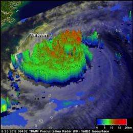
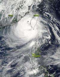
NASA's Aqua satellite captured an image of Tropical Storm Tembin after it made a quick track across southern Taiwan and re-emerged over the open waters of the Philippine Sea.
On Aug. 24 at 05:15 UTC (12:15 a.m. EDT), NASA's Aqua satellite flew over Tropical Storm Tembin and the Moderate Resolution Imaging Spectroradiometer (MODIS) instrument captured a visible image of the storm after it had crossed southern Taiwan and re-emerged into the waters of the Philippine Sea. After Tembin interacted with the land, the storm's eye was no longer visible. The storm has also become somewhat larger since crossing Taiwan and weakening. Tropical-storm-force winds extend out 145 nautical miles (170 miles/268.5 km) from the center making the storm 290 nautical miles (333.7 miles/537.1 km) in diameter.

Warnings are still in effect in Taiwan on Aug. 24. Warning areas include: Nantou County, Yunlin County, Chiayi County, Chiayi City, Tainan City, Kaohsiung City, Pingtung County, Hualien County, Taitung County, Hengchun Peninsula, Penghu County. In the Philippines, warnings are also still in effect. Public storm warning signal #2 is in effect for the Batanes group of islands, and Public storm warning signal #1 is in effect for the Calayan and Babuyan group of islands.
On Aug. 24, Tropical Storm Tembin (known as Igme in the Philippines) had maximum sustained winds near 60 knots (69 mph/111 kmh). It was located about 180 nautical miles (207.1 miles/222.4 km) south-southwest of Taipei, Taiwan, near 22.3 North and 119.8 East. Tembin was moving to the west-southwest near 5 knots (5.7 mph/9.26 kmh) and is expected to loop.
Typhoon Bolaven is over 700 nautical miles (805 miles/1,296 km) away and doesn't appear to have any effect on Tropical Storm Tembin. Tembin is expected to make a cyclonic loop over the ocean and then head northeast through the Taiwan Strait, skirting the east coast of Taiwan as it moves toward South Korea early next week.
Provided by NASA's Goddard Space Flight Center


