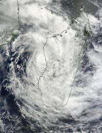
NASA's Terra satellite's MODIS instrument captured this visible image of Tropical Cyclone Irina hugging the southwestern coast of Madagascar while its center remained over the Mozambique Channel on March 1, 2012 at 0715 UTC (2:15 a.m. EST). Credit: NASA Goddard MODIS Rapid Response Team
Satellite imagery from NASA's Terra satellite today, March 1, shows Tropical Storm Irina is slow to leave the coastline of Madagascar.
When NASA's Terra satellite passed over Tropical Storm Irina on March 1 at 0715 UTC (2:15 a.m. EST), the Moderate Resolution Imaging Spectroradiometer aboard captured a visible image of the cyclone. At that time the center of the storm was still over the waters of the Mozambique Channel, but just off the central west coast of Madagascar. The storm's center was near 19.7 South and 43.7 East.
Clouds from the outer reaches of the storm stretched east over the capital city of Antananarivo, although the center was about 225 nautical miles (~259 miles/~417 km) west-northwest of the city and off-shore. Irina had maximum sustained winds near 55 knots (~63 mph/~102 kph) and was moving to the south near 14 knots (16 mph/~26 kph). Tropical-storm-force winds extended out as far as 70 nautical miles (80.5 miles/129.6 km) from the center of the storm.
As Irina continues tracking along the coast, the interaction with land is expected to keep it from strengthening. By March 2, Irina is expected to begin moving away from Madagascar and west into the Mozambique Channel. It is currently moving along the western edge of a low-to-mid level ridge (elongated area) of high pressure (centered east of Madagascar), and will soon be steered west by another building area of high pressure.
The Joint Typhoon Warning Center is forecasting a landfall north of Maputo, Mozambique sometime on March 3. Meanwhile, residents of southwestern Madagascar can expect clouds, gusty winds and rainfall from Irina over the next day or two.
Provided by NASA's Goddard Space Flight Center


