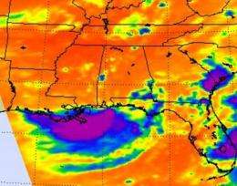
NASA's Atmospheric Infrared Sounder (AIRS) instrument on the Aqua satellite captured an infrared look at clouds from Tropical Depression 5's remnants on August 15 at 18:53 UTC (2:53 p.m. EDT) and noticed some strong convection in the southern side of circulation (purple) over the Gulf of Mexico. That area had strong thunderstorms with cloud tops as cold as -63 Fahrenheit. Credit: NASA JPL/Ed Olsen
Tropical Depression Five's remnants made a loop into southeastern Louisiana and coastal Mississippi this weekend and have again emerged in the Gulf of Mexico. Being back in the warm Gulf waters has given TD 5 a good chance for rebirth and NASA satellites are watching the storm's thunderstorms build.
The Atmospheric Infrared Sounder (AIRS) instrument on NASA's Aqua satellite captured an infrared look at TD5's clouds on August 15 at 18:53 UTC (2:53 p.m. EDT) and noticed some strong convection in the southern side of circulation over the Gulf of Mexico. That area had strong thunderstorms with cloud tops as cold as -63 Fahrenheit.
On Monday, August 16, the remnant low of TD5 was located over the northeastern Gulf of Mexico about 60 miles southwest of Panama City, Florida. The National Hurricane Center noted that "Environmental conditions are forecast to be conducive for some development of this system as it moves generally westward and then west-northwestward over the northern Gulf of Mexico during the next day or so."
TD5's remnant low pressure area will continue to do what it's done over the weekend, bring heavy rainfall wherever it goes. So, coastal areas in portions of the north central Gulf of Mexico will experience locally heavy rainfall and gusty winds through Tuesday. Meanwhile, TD5 has a 60 percent chance of being reborn as "Tropical Depression 5" again.
Provided by NASA's Goddard Space Flight Center


