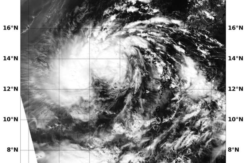
On Nov. 5, 2019 at 2:05 a.m. EDT (0705 UTC) the MODIS instrument that flies aboard NASA's Aqua satellite provided a visible image of Matmo's remnants. The MODIS image showed that the low pressure area is developing thunderstorms around its center and western quadrant. Credit: NASA/NRL On Nov. 5 at 2:05 a.m. EDT (0705 UTC) the MODIS instrument that flies aboard NASA’s Aqua satellite provided a visible image of Matmo’s remnants. The MODIS image showed that the low pressure area is developing thunderstorms around its center and western quadrant. Credit: NASA/NRL
NASA's Aqua satellite captured an image of the remnants of Tropical Cyclone Matmo in the Arabian Sea is it headed north toward Bangladesh. The visible image showed that the low pressure area appeared better organized and forecasters are watching it for regeneration.
On Nov. 4 at 1 p.m. EDT (1800 UTC) Matmo's center of circulation was located near latitude 13.3 degrees north and longitude 92.2 degrees east. That's about 514 nautical miles south of Chittagong, Bangladesh.
The Joint Typhoon Warning Center noted that, "Global computer models are depicting a slow-developing system reaching 35 knots (40 mph/65 kph) after 72 hours while on a meandering north-northwestward track. Development potential for the remnants of 23W (Matmo) is being assessed as 'medium' based on its current structure, despite the late formation timeline in global models." Maximum sustained surface winds were estimated at 20 knots (23 mph/37 kph) to 25 knots (29 mph/46 kph).
On Nov. 5 at 2:05 a.m. EDT (0705 UTC) the Moderate Imaging Spectroradiometer or MODIS instrument that flies aboard NASA's Aqua satellite provided a visible image of Matmo's remnants. The MODIS image showed the low pressure area is developing thunderstorms around its center and western quadrant. Forecasters are looking at the visible imagery, in addition to other satellite imagery, to determine if the storm has regenerated.
JTWC noted that the potential for the development of a significant tropical cyclone within the next 24 hours has upgraded to medium.
NASA's Aqua satellite is one in a fleet of NASA satellites that provide data for hurricane research.
More information: For updated forecasts, visit: www.nhc.noaa.gov
Provided by NASA's Goddard Space Flight Center


