The collection contains twenty six published papers covering various aspects of ecosystem service mapping and assessment. Credit: One Ecosystem
Methods, data, practical applications and research insights to guide scientists and practitioners through the process of mapping and assessment of ecosystems and their services are the topic of the latest open science collection published in the open access journal One Ecosystem.
The new Special Issue gives a 360-degree insight into the main results and shares experience from the three-and-a-half-year-long EU Horizon 2020-funded collaboration project ESMERALDA—Enhancing ecoSysteM sERvices mApping for poLicy and Decision mAking.
Focused on delivering a 'flexible methodology' to provide the building blocks for pan-European, national and regional ecosystem services mapping and assessment, ESMERALDA has generated a great deal of research insights and practical solutions on the topic.
While the main aim of the project has been to support Action 5 of the 2nd Target of the European Union's Biodiversity Strategy 2020, which sets the requirements for an EU-wide ecosystem services knowledge base, through its open science collection, the team of scientists and experts behind ESMERALDA hopes to share accumulated knowledge for a wider set of end-users and support them in their assessments required for instance for spatial planning, agriculture, climate, water and nature policy.
In its end-of-project Special Issue ESMERALDA shares results ranging from tested methods, collected datasets and case study experience, directly applicable to a range of practical situations, towards research papers that aim to support further scientific effort in the field.
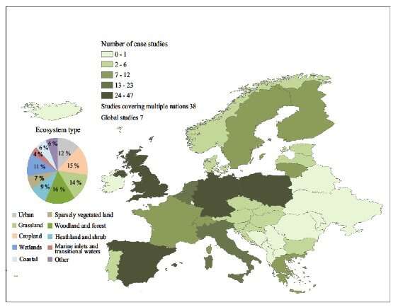
Spatial distribution of case study locations by country and type of ecosystem, in which the mapping and assessment methods were applied within ESMERALDA. Credit: Vihervaara, P. et al. 10.3897/oneeco.4.e26368
To date the collection contains twenty six published papers.
Five Method papers give insights on various aspects of mapping and assessing ecosystem services including: mapping control of erosion rates, methodology for the evaluation of ecosystem service at the national level and guidelines for the application of expert-based matrix approach for ecosystem services assessment and mapping.
A Software Description paper describes the ESMERALDA online method database for mapping and assessing ecosystem services, which could operate as a starting point for further applied research, where the application of existing standards and to be derived ecosystem services standards are getting more into focus.
Other practical outputs include various Case Studies providing, for example insights from integrated mapping and assessment of ecosystems and their services in Bulgaria, as well as an Ecosystem Service Mapping of biodiversity hotspots from the Outermost Regions and Overseas Countries and Territories of the European Union. Additionally, a Policy Brief provides a policy-friendly summary of the updated Common International Classification for Ecosystem Services (CICES V5.1).
To date, a total of eight Research papers provide project-accumulated knowledge on method database creation, case study identification techniques, methods for assessing urban recreation ecosystem services and more.
"When we finish this collection, we hope to have shared a great deal of both research insights and practical knowledge for scientists and practitioners to use and build on," comments ESMERALDA's Coordinator Prof. Benjamin Burkhard from Leibniz University Hannover. "Being a major legacy of ESMERALDA, we hope that in the future this open resource will drive some real-world results outside of the project.'
Provided by Pensoft Publishers


