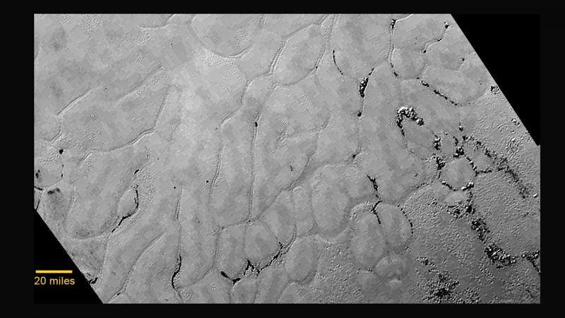
In the center left of Pluto’s vast heart-shaped feature – informally named “Tombaugh Regio” - lies a vast, craterless plain that appears to be no more than 100 million years old, and is possibly still being shaped by geologic processes. This frozen region is north of Pluto’s icy mountains and has been informally named Sputnik Planum (Sputnik Plain), after Earth’s first artificial satellite. The surface appears to be divided into irregularly-shaped segments that are ringed by narrow troughs. Features that appear to be groups of mounds and fields of small pits are also visible. This image was acquired by the Long Range Reconnaissance Imager (LORRI) on July 14 from a distance of 48,000 miles (77,000 kilometers). Features as small as one-half mile (1 kilometer) across are visible. The blocky appearance of some features is due to compression of the image. Credit: NASA/JHUAPL/SWRI
Vast frozen plains exist next door to Pluto's big, rugged mountains sculpted of ice, scientists said Friday, three days after humanity's first-ever flyby of the dwarf planet.
The New Horizons spacecraft team revealed close-up photos of those plains, which they're already unofficially calling Sputnik Planum after the world's first man-made satellite.
"Have a look at the icy frozen plains of Pluto," principal scientist Alan Stern said during a briefing at NASA headquarters. "Who would have expected this kind of complexity?"
Stern described the pictures coming down from 3 billion miles away as "beautiful eye candy."
"I'm still having to remind myself to take deep breaths," added Jeff Moore, head of the New Horizons geology team at NASA's Ames Research Center in California. "I mean, the landscape is just astoundingly amazing."
Spanning hundreds of miles, the plains are located in the prominent, bright, heart-shaped area of Pluto. Like the mountains unveiled Wednesday, the plains look to be a relatively young 100 million years old—at the most. Scientists speculate internal heating—perhaps from icy volcanoes or geysers— might still be shaping these crater-free regions.
"This could be only a week old for all we know," Moore said. He stressed that scientists have no hard evidence of erupting, geyser-like plumes on Pluto—yet.
Another possibility could be that the terrain, like frozen mud cracks on Earth, formed as a result of contraction of the surface.
This Tuesday, July 14, 2015 image provided by NASA on Wednesday shows a region near Pluto's equator with a range of mountains captured by the New Horizons spacecraft. (NASA/JHUAPL/SwRI via AP)
The plains—which include clusters of smooth hills and fields of small pits—are covered with irregular-shaped, or polygon, sections that look to be separated by troughs. Each section is roughly 12 miles (20 kilometers) across.
The height of the hills is not yet known, nor their origin. It could be the hills were pushed up from below, or are knobs surrounded by eroded terrain, according to Moore. The fields of pits resemble glacial fields on Earth.
As of Friday's news conference, New Horizons was just over 2 million miles (3.2 million kilometers) past Pluto and operating well. The spacecraft on Tuesday became the first visitor to the 4.5 billion-year-old Pluto, sweeping within 7,700 miles (12,400 kilometers) of its icy surface after a journey of 9½ years. It represented the last planetary stop on NASA's grand tour of the solar system, begun a half-century ago.
"I'm a little biased, but I think the solar system saved the best for last," Stern, a Southwest Research Institute planetary scientist, told reporters.
On Wednesday—just one day after the historic flyby—Stern and his team unveiled zoom-in photos showing 11,000-foot mountain ranges on Pluto, akin to the Rockies here on Earth. The plains are the mountains' neighbors to the north. The peaks are now known, informally at least, as the Norgay Montes. Tenzing Norgay was the Sherpa guide for Sir Edmund Hillary when they conquered Mount Everest in 1953.
The huge, encompassing heart-shaped region already bears the last name of Clyde Tombaugh, the late American astronomer who discovered Pluto in 1930.
New Horizons' science team promised Friday that the data will allow them to produce elevation maps of both Pluto and its big moon Charon.
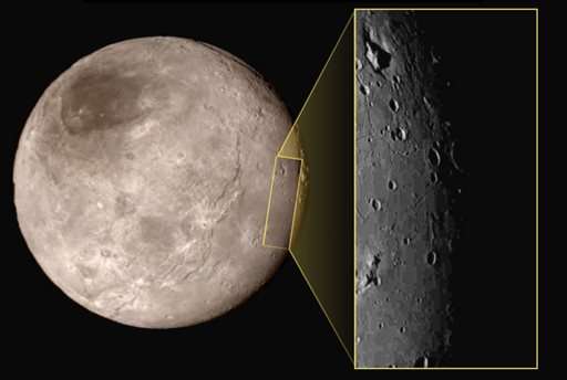
This photo taken Tuesday, July 14, 2015, at approximately 6:30 a.m. EDT, shows Pluto's largest moon Charon, left, with a captivating feature, a depression with a peak in the middle, shown in the upper left corner of the inset image at right. (NASA/JHUAPL/SwRI via AP)
It will take 16 months to transmit to Earth all the data collected during the close encounter. The Johns Hopkins University Applied Physics Laboratory is managing the $720 million mission, which began with a launch from Cape Canaveral, Florida, in 2006—months before Pluto was demoted from a full-fledged planet.
Stay tuned, meanwhile, for NASA's next Pluto update—next Friday. The pictures should keep getting better and better.
"This is just a taste of what I'm sure is in the unsent data" yet to come, Moore said.
___
Online:
NASA: nasa.gov/mission_pages/newhorizons/main/" target="_blank">www.nasa.gov/mission_ … es/newhorizons/main/
Johns Hopkins University: pluto.jhuapl.edu" target="_blank">pluto.jhuapl.edu
© 2015 The Associated Press. All rights reserved.


