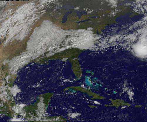
On Sunday, Oct. 12, NOAA GOES-East satellite saw Fay near Bermuda and clouds associated with a cold front over the US that are expected to absorb Fay sometime on Monday, Oct. 13. Credit: NASA/NOAA GOES Project
Tropical Storm Fay is affecting Bermuda on Sunday, Oct. 12, but a cold front over the eastern U.S. is expected to absorb the storm over the next day or two. Both were seen in an image from NOAA's GOES-East satellite.
On Saturday, Oct. 11, Tropical Depression 7 became Tropical Storm Fay in the Atlantic. By Oct. 12, Fay was nearing hurricane strength while it was less than 100 miles from Bermuda. NOAA's GOES-East satellite captured an image of the storm.
On Sunday, Oct. 12, Bermuda was placed under a Hurricane Watch and Tropical Storm Warning as Fay neared. NOAA GOES-East satellite provided an image of Fay near Bermuda that showed clouds associated with a cold front over the U.S. that are expected to absorb Fay sometime on Monday, Oct. 13. The image was created by the NASA/NOAA GOES Project at NASA's Goddard Space Flight Center in Greenbelt, Maryland.
At 8 a.m. EDT on Saturday, October 11, 2014, the center of tropical storm fay was located near latitude 27.1 north and longitude 65.2 west. The storm was moving toward the north near 12 mph. Maximum sustained winds were near 60 mph.
Twenty four hours later on Sunday, Oct. 12, Fay's maximum sustained winds were near hurricane-strength at 70 mph (110 kph), although little change in strength is forecast during the next 24 Hours. Fay is expected to become a post-tropical cyclone at night (on Oct. 12).
The center of tropical storm fay was near latitude 33.4 north and longitude 63.9 west, just about 85 miles (140 km) north-northeast of Bermuda. Fay was moving toward the north-northeast near 20 mph (31 kph) and the National Hurricane Center forecasts a turn toward the east-northeast and faster forward movement. On the forecast track, the center of Fay will continue to move away from Bermuda today.
By Monday, Oct. 12, Fay is expected to be absorbed by a cold front.
This animation of imagery from NOAA GOES-East satellite from Oct. 10-12 shows the movement of Tropical Storm Fay in the Atlantic an approaching cold front over the eastern US. Credit: Image Credit: NASA/NOAA GOES Project
Provided by NASA's Goddard Space Flight Center


