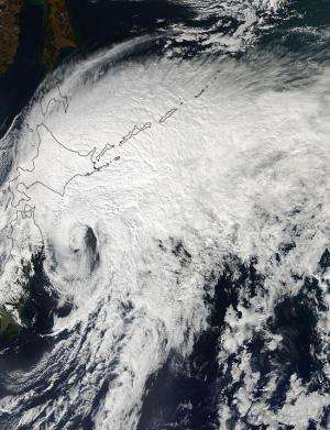
The MODIS instrument aboard NASA's Aqua satellite captured this image of Tropical Storm Vongfong over Japan on Oct. 14 at 03:15 UTC as it was southeast of the island of Hokkaido, Japan. Credit: NASA Goddard MODIS Rapid Response Team
NASA's Aqua satellite passed over Extra-Tropical Storm Vongfong on Oct. 4 as it was moving away from Hokkaido, Japan, the northernmost of the big islands. Vongfong transitioned into an extra-tropical storm early on Oct. 4 as its core changed from warm to cold.
The MODIS or Moderate Resolution Imaging Spectroradiometer instrument aboard NASA's Aqua satellite captured a visible image of Tropical Storm Vongfong over Japan on Oct. 14 at 03:15 UTC as it was southeast of the island of Hokkaido, Japan. The image showed that south of the center of circulation was almost devoid of clouds and showers, which were all pushed to the north and east of the center as a result of southwesterly wind shear.
At 0300 UTC on Oct. 14, the Joint Typhoon Warning Center issued its final advisory on Tropical storm Vongfong. At that time Vongfong's center was located near 29.1 north latitude and 142.9 east longitude, about 111 nautical miles (127.7 miles/205.6 km) southeast of Misawa, Japan. Vongfong was moving to the northeast at a speedy 36 knots (41.4 mph/66.67 kph). Vongfong's maximum sustained winds were near 35 knots (40.2 mph/64.8 kph).
Vongfong had transitioned into an extra-tropical system and will continue to move away from northern Japan and over the northwestern Pacific Ocean.
Provided by NASA's Goddard Space Flight Center


