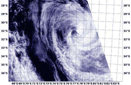
This visible image of Tropical Cyclone Colin was captured by NASA's Aqua satellite as the storm was becoming extra-tropical and elongating on January 15 at 4:25 a.m. EST. Credit: NRL/NASA
Tropical Cyclone Colin is becoming an extra-tropical system in the Southern Pacific Ocean and NASA's Aqua satellite captured an image of the transitioning storm.
The Joint Typhoon Warning Center issued their final warning on Colin on January 15 at 1500 UTC/10 a.m. EST. At that time, Colin had maximum sustained winds near 35 knots/40 mph/62 kph and was weakening. It was centered near 31.8 south latitude and 77.7 east longitude, about 1,090 nautical miles/1,254 miles/2,019 km northeast of Kerguelen Island. Colin was moving to the southeast at 23 knots/26.4 mph/42.6 kph.
As NASA's Aqua satellite passed over Colin the Moderate Resolution Imaging Spectroradiometer or MODIS instrument captured a visible image of the changing storm on January 15 at 0925 UTC/4:25 a.m. EST. The MODIS image revealed that Colin had become slightly elongated as a result of increasing vertical wind shear. The visible image also showed that the bulk of cloud cover (and shower activity) has been pushed east of the center.
A conversion to "extra tropical" status means that the area of low pressure (Colin) eventually loses its warm core and becomes a cold-core system. During the time it is becoming extra-tropical the cyclone's primary energy source changes from the release of latent heat from condensation (from thunderstorms near the storm's center) to baroclinic (temperature and air pressure) processes. When a cyclone becomes extra-tropical it will usually connect with nearby fronts and or troughs (extended areas of low pressure) consistent with a baroclinic (pressure) system. When that happens it appears the system grows larger while the core weakens.
Colin is becoming embedded in the mid-latitude westerlies (winds) and is expected to be extra-tropical late on January 15.
Provided by NASA's Goddard Space Flight Center


