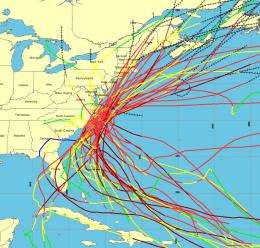
Graphic from NOAA's Historical Hurricane Tracks tool shows all hurricanes passing within 65 nautical miles of Cape Hatteras, N.C., since 1900. Credit: NOAA
An updated NOAA website lets everyone from reporters to city planners track local historical storm activity, review specific storm tracks and obtain information about a particular storm’s landfall. NOAA’s Historical Hurricane Tracks website and mapping application generates customized, downloadable maps based on more than 150 years of Atlantic hurricane data.
The Historical Hurricane Tracks tool, developed by NOAA’s Coastal Services Center in partnership with the National Hurricane Center, allows users to search by U.S. zip code, state or county, storm name or year, or latitude and longitude points. With the search results, users can generate a map showing the storm track accompanied by a table of related information.
“Understanding the history of hurricane landfalls in your community is an important step toward assessing your vulnerability to these potentially devastating storms,” said Ethan Gibney, a senior geospatial analyst for the NOAA Coastal Services Center and one of the site’s developers. “If people can see the historical impacts, they can start to understand what is ahead, particularly in light of important changes like sea level rise and eroding coastlines.”
The site includes tropical cyclone data and information on coastal county hurricane strikes through 2009. It also features a searchable database of population changes versus hurricane strikes for U.S. coastal counties from 1900 to 2000 and includes detailed reports on the life history and effects of U.S. tropical cyclones since 1958.
Provided by NOAA


