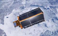
CryoSat-2 mission reveals major Arctic sea-ice loss

Arctic sea ice volume has declined by 36 per cent in the autumn and 9 per cent in the winter between 2003 and 2012, a UK-led team of scientists has discovered.
Researchers used new data from the European Space Agency's CryoSat-2 satellite spanning 2010 to 2012, and data from NASA's ICESat satellite from 2003 to 2008 to estimate the volume of sea ice in the Arctic.
They found that from 2003 to 2008, autumn volumes of ice averaged 11,900 cubic kilometres. But from 2010 to 2012, the average volume had dropped to 7600 cubic kilometres – a decline of 4300. The average ice volume in the winter from 2003 to 2008 was 16,300 cubic kilometres, dropping to 14,800 cubic kilometres between 2010 and 2012 – a difference of 1500.
'The data reveals that thick sea ice has disappeared from a region to the north of Greenland, the Canadian Archipelago, and to the northeast of Svalbard,' says Dr Katharine Giles, a NERC-funded research fellow at the Centre for Polar Observation and Modelling (CPOM) at UCL (University College London), who co-authored the report, recently published online in Geophysical Research Letters.
The findings confirm for the first time that the decline in sea-ice coverage in the Arctic has been accompanied by a substantial decline in ice volume.
They also prove the continuing decline in Arctic sea-ice volume simulated by the Pan-Arctic Ice-Ocean Modelling and Assimilation System (PIOMAS), which estimates the volume of Arctic sea ice, and had been checked using earlier submarine, mooring, and satellite observations until 2008.
An influential computer model, PIOMAS has been used to predict when Arctic summers might be ice-free.
Other satellites have already shown drops in the area covered by Arctic sea ice as the climate has warmed, especially in the summer. Indeed, the past six years have seen the lowest summer ice extent in three decades, reaching a record minimum of 3.61 million square kilometres.
But CryoSat-2, launched in April 2010, differs in that it lets scientists estimate the volume of sea ice – a much more accurate indicator of the changes taking place in the Arctic.
'While two years of CryoSat-2 data aren't indicative of a long-term change, the lower ice thickness and volume in February and March 2012, compared with same period in 2011, may have contributed to the record minimum ice extent during the 2012 autumn,' says Professor Christian Haas of York University, Canada Research Chair for Arctic Sea Ice Geophysics, co-author of the study and coordinator of the international CryoSat sea ice validation activities.
CryoSat-2 measures ice volume using a high-resolution synthetic aperture radar altimeter, which fires pulses of microwave energy down towards the ice. The energy bounces off both the top of sections of ice and the water in the cracks in between. The difference in height between these two surfaces let scientists calculate the freeboard – the height of ice above the water – and then the volume of the ice.
The satellite was launched in April 2010 to monitor changes in both the thickness and shape of ice at the poles.
The team confirmed CryoSat-2 estimates of ice volume using measurements from three independent sources – aircraft, moorings, and NASA's Operation IceBridge.
The research was funded by the Natural Environment Research Council, the European Space Agency, the German Aerospace Center, Alberta Ingenuity, NASA, the Office of Naval Research and the National Science Foundation.
Professor Seymour Laxon, who was the director of CPOM and principal scientist for several ESA missions, led the study. Tragically, he died in early January. Professor Laxon was part of the UCL team that proposed CryoSat to ESA in 1999, and was a key figure during the development and operational phases of the mission.
More information: Laxon, S. et al. CryoSat-2 estimates of Arctic sea ice thickness and volume. Geophysical Research Letters, 28 January 2013.
Journal information: Geophysical Research Letters
Provided by PlanetEarth Online


