NASA catches heavy rainfall happening in Category 4 Earl as it approaches the US

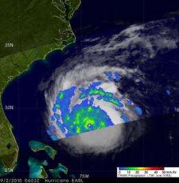
Hurricane Earl is still a powerful category four hurricane on the Saffir-Simpson Scale as it approaches the North Carolina coast today. NASA's Tropical Rainfall Measuring Mission (TRMM) satellite observed the high rates rain was falling within Earl, in some areas more than 2 inches per hour. Today, the Global Hawk unmanned aircraft is also flying into the eye of Hurricane Earl at altitudes of 60,000 feet to gather information about the storm.
Hurricane Earl became the most powerful hurricane of the 2010 Atlantic season early on September 2 when its sustained winds reached 120 kts (~138 mph). It was still intensifying when the TRMM satellite passed near its location on 2 September 2010 at 0602 UTC (2:02 a.m. EDT). The TRMM Microwave Imager (TMI) data were used in the rainfall analysis that showed heavy rainfall, particularly in the northwest quadrant of Earl's very distinct circular eye. TRMM is managed by NASA and the Japanese Space Agency, and images are created at NASA's Goddard Space Flight Center, Greenbelt, Md.
As NASA's Genesis and Rapid Intensification experiment (GRIP) continues to investigate tropical cyclones until Sept. 30, the unmanned Global Hawk aircraft was making fly overs of Hurricane Earl today to gather data from 60,000 feet high, into the lower levels of the stratosphere. This data will help scientists learn about the rapid intensification of Earl, who went from a Category 2 to a Category 4 hurricane earlier this week.
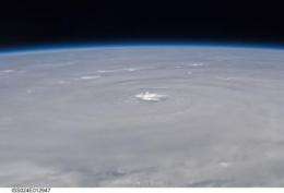
In addition to the GRIP Mission, astronauts aboard the International Space Station are also capturing Hurricane Earl on video and in photographs. These images complement the Global Hawk's view closer to Earth. In addition, NASA satellites, such as the Aqua satellite are capturing views of Earl . The Moderate Resolution Imaging Spectroradiometer (MODIS) instrument has been providing high-resolution views of Earl's clouds since it was born. To see an image from Sept. 1 at 18:01 UTC (2:01 p.m. EDT) of Hurricane Earl as it was moving through the Bahamas, go here.

Today, September 2, Hurricane warnings extend from North Carolina north to Massachusetts, including Cape Cod and the islands, with tropical storm warnings that include Virginia, eastern Maryland, New Jersey, New York, Connecticut and Rhode Island. Hurricane Earl's eye is expected to stay off-shore and eastern North Carolina and eastern Massachusetts have the strongest warnings.
At 11 a.m. EDT on September 2, Hurricane Earl had maximum sustained winds near 140 mph. It was 300 miles south of Cape Hatteras, NC, and 765 miles south-southwest of Nantucket, Mass. near 30.9N and 74.8W. It is moving north at 18 mph and has a minimum central pressure of 932 millibars.
For complete watches and warnings, and forecast track, go to the National Hurricane Center's webpage: www.nhc.noaa.gov.
NASA satellite imagery indicates this is a large storm, with hurricane force winds extend outward up to 90 miles from the center and tropical storm force winds extend outward up to 230 miles.
Provided by NASA's Goddard Space Flight Center


