Hurricane warnings posted on US East Coast, NASA sees Earl's heavy rainfall

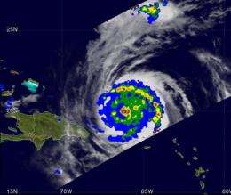
NASA's Tropical Rainfall Measuring Mission, or TRMM satellite looked at the rate rain was falling in Hurricane Earl yesterday, and it was intense.
The TRMM satellite passed close to Hurricane Earl's position early on August 31 at 0439 UTC (12:39 a.m. EDT) collecting data used in the TRMM Microwave Imager (TMI) rainfall analysis. At that time, TRMM observed a band of rain drenching Puerto Rico as it spiraled into the powerful hurricane. At the time Earl had become a powerful category four hurricane with wind speeds of about 115 knots (~132 mph). Very heavy rainfall of over 50 mm/hr (2 inches) clearly defined the location of Earl's eye wall. TRMM is managed by NASA and the Japanese Space Agency.
Another NASA satellite analyzed Hurricane Earl's cloud temperatures and thunderstorms. High, cold thunderstorm cloud tops indicate powerful storms. NASA's Atmospheric Infrared Sounder (AIRS) instrument flies aboard the Aqua satellite and captured an infrared image of Hurricane Earl today, Sept. 1 at 06:53 UTC (2:53 a.m. EDT). It showed high, powerful thunderstorms circle the center providing the heat engine for the hurricane. Earl's eye was not visible in the image, possibly because it was going through eyewall replacement, which usually occurs in major hurricanes.
On September 1 at 1500 UTC (11 a.m. EDT), Earl was a Category 3 hurricane with maximum sustained winds near 125 mph. Earl's center was located about 725 miles south-southeast of Cape Hatteras, N.C. near 25.1 North and 72.1 West. It is moving to the northwest near 17 mph, and had a minimum central pressure of 943 millibars.
Earl is a large storm, with tropical storm-force winds extending out from the center to 200 miles, and hurricane-force-winds extending out 90 miles from the center. The extent of hurricane-force winds has increased since yesterday.

A Hurricane warning is in effect from Bogue Inlet,N.C. to the N.C./V.A. border, including Pamlico and Albemarle Sounds. That means that hurricane conditions expected within 36 hours. A Hurricane watch has been posted from the North Carolina/Virginia border to Cape Henlopen, Delaware. That means Hurricane conditions expected within 48 hours. Tropical storm warning is in effect from Cape Fear, N.C. to west of Bogue Inlet, N.C. and San Salvador Island, Central Bahamas. That means Tropical storm conditions expected within 36 hours.
What can be expected? A storm surge of 3 to 5 feet above normal tidal levels expected in the warning area, with large and destructive waves. Large swells should affect the Bahamas and southeastern U.S. today. In terms of rainfall, the Bahamas and extreme eastern North Carolina, including Outer Banks, can expect 1 to 2 inches, locally up to 4 inches of rain.
Earl is expected to maintain intensity for the next few days, as it moves northwest, then north.
Provided by NASA's Goddard Space Flight Center


