2 NASA satellites capture Hurricane Bill's 'baby pictures'

Bill was the third tropical depression in the Atlantic Ocean hurricane season, behind Ana and Tropical Depression One. Over the weekend Bill grew into the first hurricane in the Atlantic this season. Two NASA Satellites captured Bill's rainfall and cloud temperatures as he was powering up.
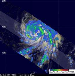
Hurricane Bill was upgraded to a hurricane by the National Hurricane Center (NHC) in Miami, Florida on August 17 at 5 a.m. EDT. The Tropical Rainfall Measuring Mission (TRMM) satellite flew over hurricane Bill a short time later at 1133 UTC (7:33 a.m. EDT) and captured Bill's "baby picture" shortly after he became a hurricane.
Data from the TRMM over flight was used in making the rainfall analysis at NASA's Goddard Space Flight Center in Greenbelt Md. The rainfall analysis showed that Bill was already a large and well- organized hurricane. TRMM's Microwave Imager and Precipitation Radar instruments revealed that Bill has bands of heavy rainfall.

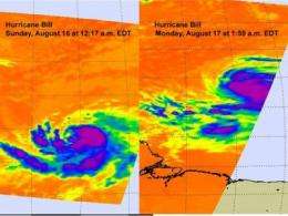
NASA's Aqua satellite captured Hurricane Bill on August 16 at 12:17 a.m. EDT and August 17 at 1:50 a.m. with the Atmospheric Infrared Sounder (AIRS) instrument. AIRS measures cloud temperature using infrared light. In NASA's infrared imagery, the false-colored purple clouds are as cold as or colder than 220 Kelvin or minus 63 degrees Fahrenheit (F). The blue colored clouds are about 240 Kelvin, or minus 27F. The colder the clouds are, the higher they are, and the more powerful the thunderstorms are that make up the cyclone and Bill has some high thunderstorms.
On Monday, August 17 at 11 a.m. EDT, Bill continued strengthening and is expected to become a major hurricane - that is a Category Three hurricane, by Wednesday. Today, however, Bill had sustained winds near 90 mph, and the hurricane force winds extended 30 miles out from the center. Bill was moving west-northwest near 16 mph and had a minimum central pressure near 977 millibars. Bill was centered about 1,080 miles east of the Lesser Antilles, near 14.1 north and 45.2 west.
Bill is predicted by the NHC to become a dangerous category three storm in the next three days with winds of 110 knots (~126.5 miles per hour).
Source: NASA/Goddard Space Flight Center


