NASA sees Koppu moving across the Philippines

NASA's Terra satellite and RapidScat gathered data on Typhoon Koppu before and after it made landfall in the northern Philippines.
Koppu made landfall in eastern Luzon on Oct. 17 EDT (1 a.m. local time Sunday morning, Oct. 18) near Casiguran in Luzon's Aurora province. Koppu is known locally in the Philippines as "Lando" and had triggered many warnings.
As the storm was making landfall, the Visible Infrared Imaging Radiometer Suite (VIIRS) instrument aboard NASA-NOAA's Suomi NPP satellite looked at the super typhoon on Oct. 17 at 1804 UTC (2:04 p.m. EDT). The infrared VIIRS image showed powerful thunderstorms wrapping around the center of circulation with cloud top temperatures as cold as -81F/-63C/210K.
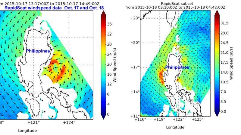
The RapidScat instrument that flies aboard the International Space Station passed over Koppu twice, 9 hours apart between Oct. 17 and Oct. 18 while it was over land. RapidScat gathers data over open ocean, and even with the center of the storm not visible on Oct. 18 it was is clear that it had maintained typhoon strength. On Oct. 17, RapidScat showed strongest sustained winds around the eye of the typhoon at 40 meters per second (89.4 mph/ 144 kph). On Oct. 18, as the western quadrant moved into the South China Sea, winds in that side of the storm were as strong as 34 meters per second (76 mph/122.4 kph).
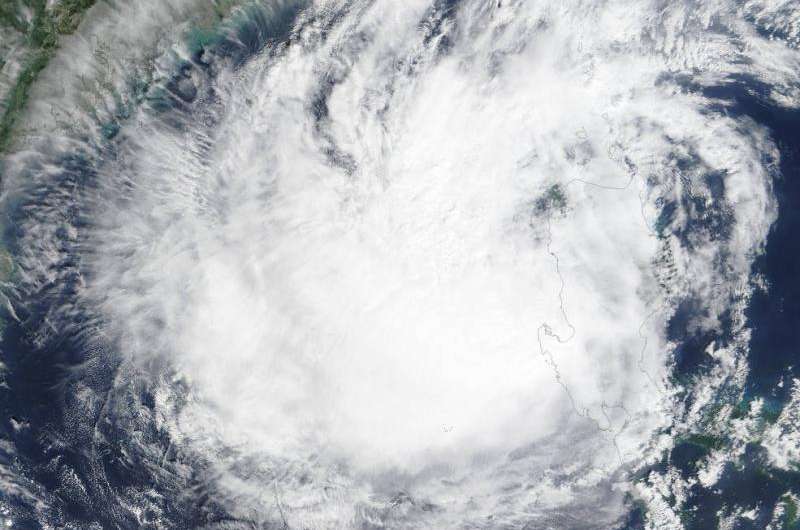
By Oct. 19 at 3:05 UTC (11:05 p.m. EDT, Oct. 18) when NASA's Terra satellite passed over the storm it had weakened to a tropical storm and was centered over the South China Sea. The Moderate Resolution Imaging Spectroradiometer (MODIS) instrument that flies aboard NASA's Terra satellite saw the storm's eastern quadrant still over the northern Philippines.
At 1500 UTC (11 a.m. EDT) on Oct. 19, Koppu was centered near 18.3 North latitude and 120.5 East longitude, about 224 nautical miles (258 miles/415 km) north of Manila, Philippines. Koppu was moving north-northeast at 4 knots (4.6 mph/7.4 kph). Maximum sustained winds had dropped to 60 knots (69 mph/111 kph).

Many warnings remained in effect in the Philippines on Oct. 19. Public storm warning signal #2 was in effect in Ilocos Norte, Ilocos Sur, Abra, Apayao, Kalinga, Mt. Province and Cagayan including Calayan and Babuyan group of islands. Public storm warning signal #1 was in effect in La Union, Pangasinan, Ifugao, Benguet, Batanes, Isabela, Quirino, Aurora, Nueva Vizcaya, Nueva Ecija, Zambales, Tarlac and Pampanga.
The Joint Typhoon Warning Center expects Koppu to continue to weaken as it moves northeast before heading north toward Taiwan. For watches and warnings in Taiwan, visit: http://www.cwb.gov.tw/eng/.
Provided by NASA's Goddard Space Flight Center


