NASA's GPM sees Koppu menacing the Philippines

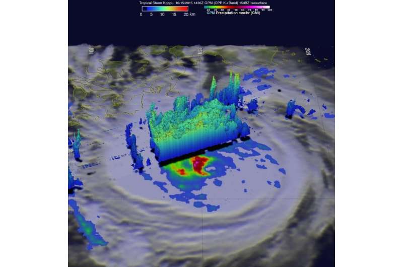
Tropical storm Koppu was approaching the Philippines when the GPM core observatory satellite passed above on October 15, 2015 at 1436 UTC (10:36 a.m. EDT) and analyzed the intensifying storm's rainfall. By October 16, the storm intensified into a typhoon as it neared Luzon.
A rainfall analysis using data collected by GPM's Microwave Imager (GMI) instrument revealed that an eye was very close to forming near Koppu's center of circulation. Rain was measured by GPM's GMI instrument dropping rain at a rate of over 133 mm (5.3 inches) per hour in intense convective thunderstorms just southwest of Koppu's center.
Data from GPM's Dual-Frequency Precipitation Radar (DPR) instrument were used to show the 3-D structure of convective thunderstorms on Koppu's western side. Some of these powerful storms were found by DPR to reach altitudes of over 14.5 km (almost 9 miles high).
Koppu is known locally as Lando in the Philippines. The Philippine Atmospheric, Geophysical and Astronomical Services Administration or PAGASA has been issuing local advisories on the system. For updated warnings and watches from PAGASA, visit: http://www.pagasa.dost.gov.ph.
Warnings remain in effect throughout various areas in the Philippines as Koppu approached on October 16. Public storm warning signal #2 is in effect in Aurora and Isabela. Public storm warning signal #1 is in effect in Cagayan, Kalinga, Mt. Province, Ifugao, Benguet, Quirino, Nueva Vizcaya, Nueva Ecija, Bulacan, Pampanga, Tarlac, Pangasinan, Rizal, Quezon including Polillo Island, Camarines Norte & Sur and Catanduanes.
On October 16, 2015 at 5 a.m. EDT/0900 UTC, the center of Typhoon Koppu was located near latitude 15.5 north and longitude 126.7 west. The storm is about 335 nautical miles (385.8 miles/ 620.8 km) east of Manila, Philippines and moving west at 8 knots (9.2 mph/14.8 kph). Maximum sustained winds were near 85 knots (97.8 mph/157.4 kph).
The Joint Typhoon Warning Center (JTWC) predicts that Typhoon Koppu will continue becoming more powerful. Koppu is predicted to have wind speeds of 115 knots (132 mph/213 kph) before making landfall in the Philippine island of Luzon.
Provided by NASA's Goddard Space Flight Center


